terça-feira, 30 de janeiro de 2018

Do tamanho de um ônibus e com o peso de um elefante: nova espécie de dinossauro é descoberta no Saara


  • Andrew McAfee/Carnegie Museum of Natural History/Reuters
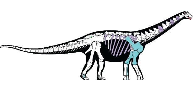
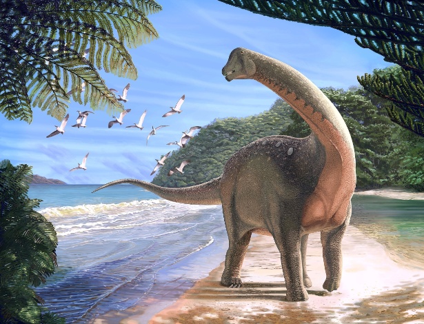
    Reconstrução do dinossauro "Mansourasaurus shahinae", que viveu há cerca de 80 milhões de anos no deserto ocidental do Egito
    Reconstrução do dinossauro "Mansourasaurus shahinae", que viveu há cerca de 80 milhões de anos no deserto ocidental do Egito
Cientistas do Egito descobriram no deserto do Saara Oriental o 'Mansourasaurus shahinae', uma nova espécie de dinossauro do período Cretáceo cujos fósseis oferecem nova informação sobre a vida destes animais ao fim de sua existência, segundo um estudo publicado nesta segunda-feira (29) na revista "Nature".
Este novo tipo de titanossauro pertence ao grupo dos saurópodes, entre os quais se encontram outros grandes herbívoros de pescoço longo como o 'Argentinossauro' e o 'Patagotitan mayorum', ambos encontrados no Cone Sul da América.

O "Mansourasaurus" encontrado no Saara egípcio tem um tamanho menor que esses dois gigantes, com um comprimento similar ao de um ônibus médio e o peso de um elefante adulto, e viveu durante o Cretáceo Tardio, entre 100 e 66 milhões de anos, num período próximo de sua extinção, informaram os responsáveis pela pesquisa, liderada pela Universidade de Mansoura.

Os restos fósseis de dinossauros dessa época, segundo os paleontólogos, são poucos, por isso sua história evolutiva no continente africano era, até agora, um mistério para os cientistas.

"O 'Mansourasaurus' nos ajudará a abordar questões pendentes sobre os registros fósseis da África e sua paleobiologia, quais os animais que viviam ali e com que outras espécies estavam (os dinossauros) aparentados de maneira mais próxima", destacou um dos coautores do estudo, Eric Gorscak.

A vegetação frondosa de algumas partes da África, segundo os especialistas, dificultou o trabalho de busca de restos fósseis, em comparação com a visibilidade de outras áreas como a do deserto de Gobi (Ásia), das Montanhas Rochosas (América do Norte) e da Patagônia (América do Sul).


Andrew McAfee/Carnegie Museum of Natural History/Reuters
Este novo tipo de titanossauro pertence ao grupo dos saurópodes
Nesse sentido, a escassez de fósseis do Cretáceo Tardio nesta região do planeta dificultou os estudos sobre essa época crucial para entender a extinção dos dinossauros, que coincidiu, além disso, com um período de profundas mudanças geológicas e geográficas.

Durante a maior parte dos períodos Triássico e Jurássico, todos os continentes atuais formavam a Pangea, o supercontinente que começou a se dividir em massas de terra separadas pelos oceanos no Cretáceo.

A informação disponível até agora não explica adequadamente que tipo de vínculos tinha a fauna africana durante essa época com outras massas terrestres do hemisfério sul e da Europa, nem como tinham evoluído em relação a seus vizinhos após a separação dos continentes.

Após analisar as características da estrutura óssea do 'Mansourasaurus shahinae', um dos poucos dinossauros do Cretáceo encontrados na África, os especialistas determinaram que este titanossauro tem mais vínculos com os da Europa e da Ásia do que com os da América do Sul e da parte meridional do continente africano.

Isto demonstra, além disso, que, ao final da sua existência como espécie, os "últimos dinossauros da África não estiveram completamente isolados, como se propunha no passado", mas que alguns "ainda mantiveram conexões com a Europa", segundo Gorscak.

Receba notícias do UOL. É g

sábado, 27 de janeiro de 2018

Pesquisadores descobrem fóssil de pinguim gigante

9b8ea533-4da6-4a27-a5b5-59ba5f530fce.jpg
(G. Mayr/INSTITUTO DE PESQUISA Senckenberg)

POR CARL ZIMMER

O fóssil de 57 milhões de anos é ao mesmo tempo cômico e assustador: um pinguim de bico longo que tinha 1,7 metro de altura e pesava cerca de 100 quilos.

“Tinha o tamanho de um homem médio”, disse o paleontólogo Gerald Mayr, do Instituto de Pesquisa Senckenberg, em Frankfurt, Alemanha, principal autor de uma reportagem publicada na edição de dezembro da Nature Communications anunciando a descoberta. Em comparação, a mais alta espécie viva deste animal, o pinguim-imperador, chega a aproximadamente 1,2 metro.
O Kumimanu biceae, como foi batizado o fóssil, não era apenas grande: está entre os mais antigos fósseis de pinguim já encontrados. Sua idade e seu tamanho fazem do Kumimanu uma peça importante para entender como aves voadoras se transformaram em animais aquáticos que não conseguem voar.

As 18 espécies modernas de pinguins, encontradas da Antártida às Ilhas Galápagos e ao Equador, são extremamente bem adaptadas à vida marinha. Asas duras semelhantes a barbatanas permitem que eles nadem a velocidades de até 35 km/h. Mas essas adaptações resultaram na perda da capacidade de voo, obrigando-os a andar desajeitadamente sobre patas atarracadas. “São tão diferentes dos pássaros que muitos ignoram que os pinguins são aves”, disse Mayr.

Mas o DNA dos pinguins indica um parentesco bastante próximo com espécies como o albatroz e o petrel. Essas aves sobrevoam a água para caçar, indicando que talvez os ancestrais do pinguim também tivessem o mesmo comportamento. Estudos indicam que os pinguins se distinguiram dos demais pássaros há cerca de 66 milhões de anos, época de uma extinção em massa no planeta.


Os primeiros fósseis de pinguins foram descobertos em 1859 e, desde então, mais de 50 espécies foram identificadas.

Waimanu, o mais antigo desses fósseis, encontrado na Nova Zelândia, é de aproximadamente 60 milhões de anos atrás. Kumimanu foi descoberto em meio a ossos presos numa rocha de uma praia neozelandesa. Os cientistas traçaram uma árvore evolucionária e descobriram que Kumimanu e Waimanu pertencem aos seus ramos mais distantes.

São espécies que já se extinguiram há dezenas de milhões de anos. Em comparação, todos os pinguins vivos pertencem a um ramo jovem da árvore. Partilham um ancestral comum que viveu há 15 milhões de anos.

Kumimanu e Waimanu não eram capazes de voar, mas apresentavam alguns traços primitivos que não são encontrados nos pinguins atuais. “Seu bico era muito mais parecido com o de uma garça”, disse Mayr. “É provável que o usassem como uma lança para caçar suas presas”.

Mayr acredita que a origem dos pinguins está ligada às extinções em massa que marcaram o início da Era Cenozoica. Subitamente, os oceanos foram esvaziados de seus maiores predadores. Os pinguins puderam se adaptar à caça submarina de suas presas sem muito a temer.

Mas, conforme os mamíferos procuraram os oceanos, evoluindo para baleias e focas, é possível que essa concorrência tenha vencido as aves. Focas e pinguins precisam de praias onde possam procriar e nutrir os filhotes. É possível que as focas tenham sufocado os pinguins gigantes, enquanto os pinguins menores sobreviveram.

“Para mim, a grande dúvida não está na imensa quantidade de pinguins no início da Era Cenozoica, mas na ausência de pinguins gigantes hoje”, disse Mayr.

sexta-feira, 26 de janeiro de 2018

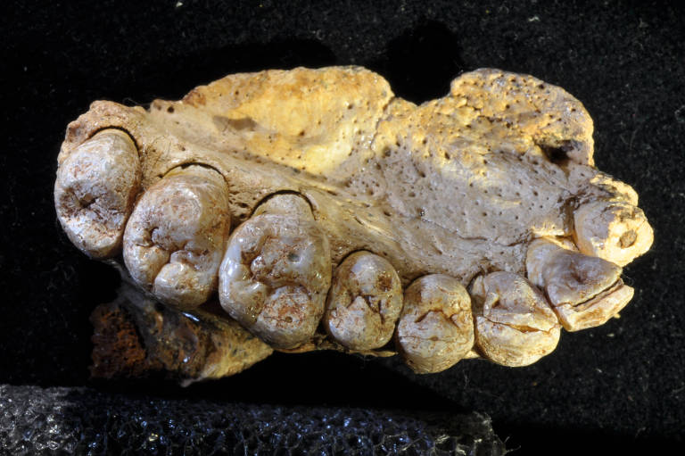
This jaw unearthed in an Israeli cave may have belonged to one of the earliest modern humans to leave Africa.
HERSHKOVITZ ET AL./SCIENCE

This ancient jawbone suggests our species left Africa 40,000 years earlier than expected

In a collapsed cave on the western slope of Mount Carmel in Israel, researchers have found the jawbone of an ancient human who may have been one of the first modern members of our species to leave Africa. Here, in a huge cave by the Mediterranean Sea, ancient people roasted hare, turtle, and ostrich eggs and knapped stone tools from flint. If the researchers’ dates of 177,000 to 194,000 years for the jaw and tools hold up, it means that modern humans left Africa 40,000 years earlier than expected. The find may have implications for when and how our species arose, and how many waves of early humans left Africa.

Before now, the earliest modern human fossils outside Africa came from the nearby Skhul Cave on Mount Carmel and Qafzeh Cave in Israel, sites dated to between 80,000 to 120,000 years old. But our species arose in Africa some 300,000 years ago, according to new dates on a skull in Morocco last year, and some researchers have claimed an early exodus from Africa based on fragmentary fossils and stone tools in the Middle East, Arabia, and China. But securely dated sites with accepted human fossils outside of Africa have been lacking.

The upper jaw described in Science today was discovered in 2002 by students digging in the floor of Misliya Cave, the remains of a collapsed cave carved into the cliffs on the western slopes of Mount Carmel, 12 kilometers south of Haifa, Israel. From the first look at the upper jawbone, which retains a complete row of teeth on its left side, the researchers knew it was a member of our species, Homo sapiens. Its canine and other teeth resemble those of the modern humans at Skhul and Qafzeh, and it lacked features found in Neandertals.

The jawbone was excavated in the same sedimentary layer as thousands of “museum quality” handaxes and flint tools, says co-author Mina Evron of the University of Haifa. The tools were crafted with a sophisticated method called Levallois technology, which requires abstract thinking. Some researchers have suggested the method was invented by H. sapiens and may mark our species’s presence and early steps out of Africa.
 
Three teams independently dated the finds using uranium isotope decay and several luminescence methods, which determine how long ago mineral grains were last exposed to light. They dated the burned flint tools to about 179,000 years (plus or minus 48,000 years), which fits with other work dating Levallois style tools in Israel to 140,000 to 250,000 years ago. They also dated a sliver of enamel from a tooth to 174,000 years, and say that crust adhering to the upper jaw is at least 185,000 years old.

The dates on the tools seem solid, dating experts say. But several question the dates on the fossil itself, partly because the authors write that the jawbone was scanned using computerized tomography three times, and the x-rays could have influenced the amount of radiation trapped in the tooth enamel, skewing the luminescence dates.

Uranium dating expert Alistair Pike of the University of Southampton in the United Kingdom notes that a crust on the jawbone “is heavily contaminated by detritus.” The contamination could bias the radiometric dates on the crust, which includes a younger date of 70,000, says geochronologist Warren Sharp of the Berkeley Geochronology Center in California. He and others also note that relying on nearby tools is problematic, because it’s possible that the bone was mixed into the tool-bearing layer later in time.
The team stoutly defends its dates, noting that its painstakingly controlled excavation links tools and fossil tightly in the same sedimentary layer and, thus, time.

If their dates are correct, “it’s mind-blowing,” says archaeologist Michael Petraglia of the Max Planck Institute for the Science of Human History in Jena, Germany, who says the find suggests that modern humans migrated out of Africa repeatedly, with multiple groups moving into the Middle East. They may have moved out of Africa when the climate was more humid 244,000 to 190,000 years ago, but gone extinct as the climate got arid again, says paleoanthropologist Marta Mirazon Lahr of the University of Cambridge in the United Kingdom, who was not involved with the new find.
The implications go back even further for co-author and physical anthropologist Israel Hershkovitz of Tel Aviv University in Israel, who says the find suggests our ancestors arose far earlier than thought. “[If] our species was in Israel 200,000 years ago, it suggests our species is very old—not just 300,000 years old, but older.”
Posted in:
doi:10.1126/science.aat1201

Homo sapiens deixou a África antes do que se pensava, indicam fósseis


Rolf Quam/Universidade de Binghamton
Parte do maxilar encontrado por pesquisadores
Parte do maxilar encontrado pelos pesquisadores em Israel

Fósseis e artefatos de pedra achados numa caverna de Israel indicam que membros da nossa espécie deixaram seu continente de origem, a África, muito antes do que se imaginava. Esses viajantes pioneiros já estariam no Oriente Médio entre 194 mil e 177 mil anos atrás –anteriormente, acreditava-se que os primeiros Homo sapiens a saírem do berço africano teriam vivido há cerca de 100 mil anos.
"Tanto os seres humanos modernos quanto hominídeos mais antigos parecem ter saído da África e voltado para lá diversas vezes ao longo dos últimos 2 milhões de anos", declarou à Folha o coordenador da equipe responsável pela descoberta, Israel Hershkovitz, do Departamento de Anatomia e Antropologia da Universidade de Tel-Aviv. "Não houve um único grande êxodo, mas infiltrações bastante lentas de pequenos grupos, uma expansão de longo prazo."

Hershkovitz e seus colegas de diversas instituições mundo afora, dos EUA à Espanha, estão publicando os resultados na edição desta semana da revista especializada "Science". Os achados vêm da caverna de Misliya, nas encostas do monte Carmelo –a mesma montanha do antigo reino de Israel celebrizada em relatos bíblicos sobre o profeta Elias.

CACO INFORMATIVO
 
Para o não especialista, a conclusão central do estudo sobre a presença de seres humanos de anatomia moderna em Misliya talvez pareça se basear em poucas evidências. Os pesquisadores encontraram apenas parte do maxilar de um indivíduo –o que inclui pedaços do céu da boca, da base do nariz e dentes que vão da raiz do primeiro incisivo até o terceiro molar (veja infográfico).

Trata-se, no entanto, de um caco altamente informativo da anatomia humana (e pré-humana). Os bioantropólogos e anatomistas costumam fazer comparações exaustivas dos detalhes do maxilar, das mandíbulas e dos dentes entre as várias etnias humanas atuais, entre povos do passado e parentes extintos do Homo sapiens. Com isso, sabem bastante bem os detalhes que nos diferenciam dos neandertais, nossos primos evolutivos de primeiro grau –um exemplo são os caninos, com formato de espátula nos neandertais, o que não se vê nos humanos modernos.

A análise é convincente, diz o britânico Chris Stringer, do Museu de História Natural de Londres, um dos principais estudiosos da origem africana da humanidade. "A combinação de traços dos fósseis é característica do H. sapiens", escreveram Stringer e sua colega Julia Galway-Witham em comentário feito a pedido da "Science". As datações, feitas com base em sedimentos da caverna, como os que tinham aderido ao maxilar, também parecem consistentes, diz a dupla.

Ao contrário do estereótipo desértico do Oriente Médio, o monte Carmelo e suas redondezas têm clima ameno e vegetação farta, com carvalhos, pinheiros e oliveiras. Cerca de 200 mil anos atrás, o ambiente ali era parecido. A principal diferença era o nível do mar, conta o pesquisador israelense – muito mais baixo do que hoje e mais distante da caverna. "Boa parte da área em frente à caverna estava ocupada por pântanos", afirma.

Para explorar esse ambiente, rico em recursos vegetais e em herbívoros de carne apetitosa, como gazelas, auroques (bois selvagens) e gamos-persas (veados típicos do Oriente Médio), os Homo sapiens de Misliya usavam artefatos de pedra relativamente sofisticados. Eles eram produzidos pela chamada técnica Levallois, que consiste em preparar uma pedra "núcleo", arrancando várias lascas nas bordas dela, pacientemente. Cria-se assim um núcleo pré-preparado que lembra o casco de uma tartaruga visto de cima. Uma última pancada arranca desse núcleo a ferramenta propriamente dita, que fica com várias bordas cortantes graças à preparação.

Essa técnica é comum em sítios habitados por neandertais, mas Hershkovitz defende que ela foi inventada pelos H. sapiens africanos e copiada pelos neandertais mais tarde (de fato, há indícios de contato entre as espécies na própria região do monte Carmelo). "Achamos mais de 60 mil artefatos com mais de 2,5 cm de comprimento", conta. "Alguns parecem ter sido usados para processar plantas, raspando, cortando ou cavando tubérculos, outros para raspar minerais, talvez ocre. Outros têm marcas de impacto nas pontas, sugerindo seu uso como projéteis para a caça. Podem ter tido cabos de madeira, como lanças, mas ainda estamos estudando esse aspecto."
A grande questão é saber como as datas obtidas pelo israelense e seus colegas se encaixam no quadro geral da expansão dos seres humanos de anatomia moderna pela Terra. Só há indícios claros da presença deles fora do Oriente Médio (encruzilhada natural da África com o resto do mundo) a partir de uns 60 mil anos atrás. Há 45 mil anos, o Homo sapiens já tinha chegado à Europa e à Austrália. A presença mais antiga em Israel poderia ser um experimento que não deu muito certo, sugere Stringer – ou novos achados em locais mais distantes podem alterar essa visão.


CÉREBRO ARREDONDADO
Enquanto a arqueologia não resolve essas dúvidas, outro estudo publicado nesta semana indica que mudanças importantes no cérebro aconteceram bem depois da origem propriamente dita dos seres humanos modernos, o que ajudaria a explicar por que o comportamento de nossos ancestrais demorou dezenas de milhares de anos para se diferenciar do de outros hominídeos mais arcaicos.

É o que argumentam Simon Neubauer e seus colegas do Instituto Max Planck de Antropologia Evolucionista, na Alemanha. Em artigo na revista "Science Advances", Neubauer e companhia publicaram os resultados de uma análise do formato do cérebro de 20 humanos anatomicamente modernos, dos mais antigos (com 300 mil anos) a amostras da pré-história mais recente (8.000 anos) e dos tempos atuais. No caso de fósseis, estimar o formato do cérebro (que se decompõe, claro) foi possível graças a técnica de tomografia computadorizada dos crânios.

Resultado: embora há 300 mil anos o cérebro humano já fosse tão grande quanto o atual, o formato mudou bastante. Originalmente mais alongado, ele foi se tornando cada vez mais globular (arredondado, grosso modo), completando essa transformação entre 100 mil e 35 mil anos atrás. É justamente a partir dessa época que começam a aparecer sinais de arte, roupas costuradas e outros comportamentos complexos associados às capacidades mentais dos seres humanos atuais. Para os pesquisadores, a reorganização do cérebro provavelmente explica essas transformações comportamentais.

sexta-feira, 19 de janeiro de 2018

Discovery Channel: Dinosaur Revolution
Reino dos Dinossauros

!


[discovery]

Excelente documentário do Discovery Channel

Basta clicar nos links abaixo para baixar os episódios!!

quinta-feira, 18 de janeiro de 2018

Dark days of the Triassic: Lost world

Did a giant impact 200 million years ago trigger a mass extinction and pave the way for the dinosaurs?

VICTOR O. LESHYK
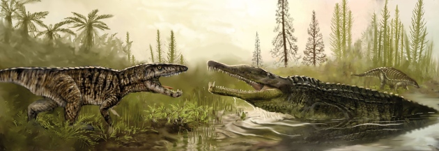
Extinctions at the end of the Triassic period killed off top predators such as Redondavenator (left), seen in an artist's impression confronting an aquatic phytosaur.

It takes a little fiddling, a few missed turns on the old, labyrinthine lanes and a good deal of folding and unfolding of an Ordnance Survey map bought that morning, but eventually Paul Olsen and Dennis Kent manage to locate the unmarked access path that leads through the woods to a desolate stretch of shoreline on Lavernock Point, a wild, cliff-lined promontory south of Cardiff in Wales, UK.
Olsen and Kent park their rental car in a muddy lay-by. A slow rain begins to fall and low peals of thunder can be heard in the distance. Grumbling good-naturedly about the British climate, the two geoscientists shrug into their parkas, sling their rucksacks over their shoulders and start down the slick path for another afternoon of getting cold, wet and muddy in the search for clues to mysterious events that wiped out much of life on Earth 200 million years ago and allowed the dinosaurs to take over the world.

How the dinosaurs' mighty reign ended has been fairly well established: a catastrophic asteroid impact near Chicxulub on the Yucatan Peninsula in Mexico, just over 65 million years ago, is widely credited with bringing the age of the dinosaurs to a close and ushering in the age of mammals.
Olsen and Kent, who both work at Columbia University's Lamont-Doherty Earth Observatory in Palisades, New York, have long speculated that with Chicxulub, history might have been repeating itself: that another asteroid, 135 million years earlier, could have wiped out, or at least had a hand in wiping out, much of the late-Triassic flora and fauna. This would have allowed dinosaurs to spread around the globe during the subsequent Jurassic period (200 million to 145 million years ago), evolve enormous bodies and dominate the planet until the next great impact catastrophe.

Sudden death

It is certain that something drastic did happen at the end of the Triassic, because in the space of a few thousand years, half of all genera known to have existed at the time suddenly vanish from the fossil record. At sea, 20% of all families abruptly disappear, including an entire class of creatures — the eel-shaped conodonts. On land, the death toll was even higher. It was one of the greatest mass extinctions in Earth's history and, at this vast distance in time, one of the least understood. “The only thing anyone can say with any certainty about the Triassic–Jurassic mass extinction is that it happened,” says Olsen. “Whatever it was that caused it, it happened so swiftly that most life forms never had time to adapt and evolve to meet the changes.”

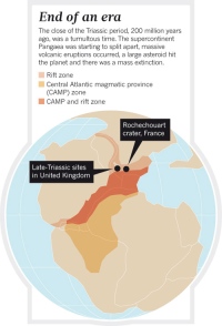
The prevailing view among scientists these days is that the extinctions were caused by massive volcanic activity associated with the break-up of the super-continent Pangaea. The series of eruptions created a vast geologic formation called the Central Atlantic magmatic province (CAMP; see 'End of an era'). “We are talking here about volcanic activity on a scale many thousands of times greater than anything ever witnessed by humans,” says Gregory McHone, an independent Canadian geologist who has spent much of his career investigating the CAMP volcanic event and building a convincing case for its involvement in the Triassic–Jurassic mass extinction.

The flood-basalt eruption of the Icelandic volcano Laki in 1783 provides researchers with a scaled-down model of just how bad things might have been in the late Triassic. An outpouring of sulphurous gases from Laki created haze that cooled the planet and caused widespread crop failures and famine. It ultimately contributed to the deaths of an estimated 6 million people, says McHone. But disastrous as Laki's eruption was, it belched up just 15 cubic kilometres of basalt. The CAMP events produced 2 million cubic kilometres or more, in a series of pulses that alternated between cooling the climate with sulphurous haze and warming it with massive emissions of carbon dioxide and methane. The oceans grew acidic and parts became starved of oxygen, while on land a surge in lightning sparked extensive fires1. Many of Earth's life forms simply couldn't recover from that succession of body blows, says McHone.

It's a plausible theory, as Olsen and Kent both readily concede — even, perhaps, the most likely one. All the same, the CAMP theory leaves a lot of unanswered questions, not least of which is the suddenness of the extinctions. The late-Triassic eruptions span hundreds of thousands of years, but the die-offs seem swift in the fossil record. And what of the 'fern spike'? Late-Triassic sediments on the US east coast contain huge quantities of fossilized fern spores.

Ferns are usually the first plant to appear after a natural disaster, says Kent. “If you look in the fossil record you see a sudden massive spike in ferns just around the time of the extinctions, but demonstrably before the great basalt flows — at least in our part of the United States.” In other spots, the extinctions seem to coincide with the oldest basalt layers, within the errors of the dating conducted so far.

“The only way we are ever going to unravel this mystery is to work out a timeline, as precise as we can make it, of all the various events around the world that led up to it,” says Kent. Pursuit of that timeline has taken Olsen and Kent on a global quest, from North Carolina to Nova Scotia, Canada; China to Germany, Italy, Austria and the High Atlas Mountains in Morocco; and now to Wales.

Just in time

Olsen has been thinking about the possibility of an impact connection to the Triassic–Jurassic extinctions for more than 20 years2, 3, but one of the biggest drawbacks to the asteroid theory is that until recently nobody had found any evidence of such a catastrophe occurring around the time of the extinctions. Then, last year, French and German research teams re-dated a badly eroded structure left by a massive impact near Rochechouart, in western France4. Previous work had put the impact at around 214 million years ago, long before the extinction event. But the revised date of 199 million to 203 million years ago overlaps with the extinctions, which have been dated to 201.4 million years ago5.
The authors of the paper also suggested that the enormous shock waves generated by the 2-kilometre asteroid, as it slammed to Earth at more than 25 kilometres per second, could account for unexplained ripples and disturbances in the late Triassic limestone and shale beds in western Britain — sedimentary beds that coincide with the mass-extinction event. “When I read that,” says Olsen, “I decided it was time to come over here and take a much closer look.”
AP/JIM ROSS
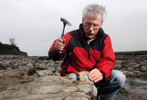
Paul Olsen inspects rocks along a beach in Wales to trace what caused one of the biggest mass extinctions on Earth.

As Olsen scrambles along the base of the Welsh cliffs, his stories bring to life the Triassic world. There were the monkey lizards with their beaky faces, long arms and grasping tails; crocodilian creatures that trotted along like dogs; and shallow tropical seas teeming with sharks, right where this shingle beach lies today. “Then suddenly it all came crashing to an end,” says Olsen.
Olsen's fascination with this lost world goes back to 1968, when he was a 14-year-old in Livingston, New Jersey, and heard that dinosaur footprints had been found in the rocks of the nearby Roseland quarry. He and a school friend hopped on their bikes, pedalled over to the quarry and found that there were fossils everywhere.

By the time the two friends were in their second year of high school, they had catalogued thousands of fossils and tracks of reptiles from the late Triassic and early Jurassic. They became so involved that when the quarry and its treasures were to be sold off and developed into housing units, the teens mounted a publicity campaign to save it.

Soon, Life magazine was on the phone and their campaign had captured national attention. Olsen even made a cast of a footprint left by a fearsome three-toed beast, and sent the fibreglass model to then-US president Richard Nixon.

The publicity garnered by this sheer chutzpah helped to protect the fossil-rich site, and the fibreglass footprint went on to find a place in Richard Nixon's presidential library.
Olsen's trip through western Britain with Kent retains some of that sense of schoolboy enterprise and science on the human scale: the two researchers bicker amiably over which way to go at the crossroads; stop off in the local supermarket to pick up more plastic sandwich bags for their rock specimens; use a self-modified, battery-powered drill to take core samples; and even get scolded by the waspish landlady at their guest house when they clomp in with muddy boots at the end of the day.

Explosive force

At Lavernock Point, the scientists ignore the rain and thunder as they set about their work. Olsen makes his way to the base of the cliffs and points to a layer of buff-coloured limestone at about waist height. “Right there is where it happened: there's the extinction line,” he says. To a layman, it is innocuous: just another of the alternating bands of limestone and shale that are brightened here and there by clumps of flowering purple valerian. But close examination reveals sand-filled cracks and deposits of grainy, irregularly sized material — disturbances that might have been the work of a tsunami or an extraordinary earthquake.

The disturbed layers here and at other late-Triassic sites in the United Kingdom have a distinctive orientation, all angled as if the source of the unrest was in the vicinity of Rochechouart, says Olsen.
It certainly would have been an awful day in this part of the world when the Rochechouart crater formed. The researchers who re-dated it estimate4 that the impact would have generated an earthquake up to magnitude 11.5 — 100 times more powerful than any quake in recorded history.
“It happened so swiftly that most life forms never had time to adapt and evolve.”
Gareth Collins, a geoscientist at Imperial College London, says that the quake would probably have been much smaller, although still massive. Collins and researchers from Purdue University in West Lafayette, Indiana, have developed an online calculator to model the effects of impacts. Their algorithm paints a vivid picture of what would have been going on at this spot in Wales after the asteroid hit with the explosive force of more than one million megatonnes of trinitrotoluene (TNT). Even at a distance of more than 600 kilometres, the beach would have endured hurricane-force winds and a hail of debris.
That debris would have carried a chemical signature of the impact that might still reside in the layers of sedimentary rocks. Stratigrapher Stephen Hesselbo and geochemist Ken Amor, both at the University of Oxford, UK, have joined Olsen and Kent on their outing, and are taking samples to analyse with a mass spectrometer. They will measure the ratios of chromium isotopes, and look for one that is characteristic of meteorites. Olsen will also send samples from this location to another lab, to be searched for other tell-tale impact markers.

If those tests detect an extraterrestrial signal in the late-Triassic sedimentary layers in Wales and elsewhere, it will be the first substantive link between an impact and the Triassic–Jurassic mass-extinction event. But a coincidence in time won't prove that an impact was the cause. “The two things might occur at approximately the same moment but have nothing whatever to do with each other,” says Olsen.

More troublingly, the Rochechouart impact doesn't seem to have been anywhere near big enough to have accounted for the mass extinctions around the globe — at least, not on its own. The 25-kilometre-wide buried crater may have been 40 to 50 kilometres across originally, but it is just a pockmark in comparison with the 180-kilometre-wide scar at Chicxulub. “Based on our estimates, Rochechouart is quite small in terms of global environmental consequences,” says Collins.

Picking up the pieces

For now, says Olsen, it is too early to make any definitive statements about what Rochechouart did or didn't do. That will take much more data from late-Triassic sites around the world. This year alone, he has crossed the Atlantic three times to collect samples from the United Kingdom and Morocco. He is back in the Atlas Mountains this week, to examine yet more sites. He and his colleagues are not only looking for signs of an extraterrestrial impact in the sediments, but are also searching for other clues, such as the extinction layer and a chemical signature that could be linked to the CAMP eruptions. All those data, says Olsen, will help the team to sort out the relative timing of events around the world, and to create a fuller picture of what happened and how life responded.

He suspects that Rochechouart may have been “a piece of a much bigger puzzle”. Perhaps it was one of a series of asteroids that hit around the same time. Alternatively, a lone French crash might have been the final straw for a world already reeling from volcanic eruptions. Or the impact may have come first, weakening ecosystems enough that when the eruptions started, life took a nosedive.
Teasing out the answer will take some time, says Olsen, as he trudges, wet and muddy, back up the trail at the end of another wearying afternoon in the cold Welsh rain. “There is no easy way to do this,” he says. “But I believe that eventually we will be able to put the pieces together and know what happened and why.”
Nature
479,
287–289
()
doi:10.1038/479287a

References

  1. Belcher, C. M. et al. Nature Geosci. 3, 426429 (2010).
  2. Olsen, P. E., Shubin, N. H. & Anders, M. H. Science 237, 10251029 (1987).
  3. Olsen, P. E. et al. Science 296, 13051307 (2002).
  4. Schmieder, M., Buchner, E., Schwarz, W. H., Trieloff, M. & Lambert, P. Meteorit. Planet. Sci. 45, 12251242 (2010).
  5. Schoene, B., Guex, J., Bartolini, A., Schaltegger, U. & Blackburn, T. J. Geology 38, 387390 (2010).

Related stories and links

From nature.com


Earliest known dino relative found

Dinosaurs originated 15 million years earlier than previously thought.
Dinossauro relativamente mais antigo conhecido encontrado

Dinossauros se originaram cerca de 15 milhões de anos mais cedo do que se pensava anteriormente.


Rights & Permissions
M. Witton/Natural History Museum, London.

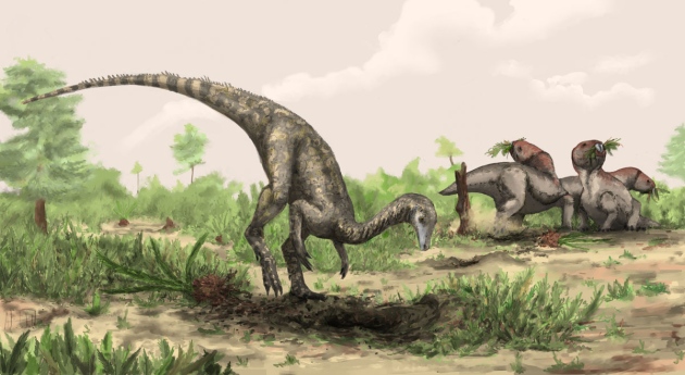
Nyasasaurus may have roamed the southern region of Pangaea during the Triassic period.
The dawn of the dinosaur era was thought to start around 230 million years ago, but a new discovery moves their origin 15 million years further back in time.

Palaeontologists have long sought the earliest dinosaurs. Now, skeletal fragments from a pair of specimens indicate that dinosaurs emerged in the wake of the largest mass extinction of all time — the crash that occurred around the transition from the Permian to the Triassic period about 252 million years ago.
At 243 million years old, Nyasasaurus parringtoni may be the oldest known dinosaur. Sterling Nesbitt, a palaeontologist at the University of Washington in Seattle, and his colleagues describe the animal in a study published today in Biology Letters1.
The fragmentary nature of the find obscures the animal's form, but based on its relationship to early dinosaurs and dinosauriform ancestors, Nesbitt expects that Nyasasaurus was a leggy, long-necked bipedal creature about “the size of a Labrador retriever".

Even if Nyasasaurus doesn’t turn out to be a true dinosaur, Nesbitt points out, the finding demonstrates that close ancestors of dinosaurs must have existed 15 million years earlier than the oldest known dinosaur, Eoraptor, found in South America. 

The age of Nyasasaurus hints that dinosaurs were just one lineage of archosaurs —‘ruling reptiles’ that include pterosaurs, crocodiles and their relatives — which proliferated in the aftermath of the Permian mass extinction. The age of dinosaurs has not yet ended. Modern birds are direct descendants of the lineage, carrying on the dinosaurian reign much like their small, svelte ancestors that scurried through Pangaea's Triassic forests.

The fossils were discovered in the 1930s in southern Tanzania by Rex Parrington, a palaeontologist at the University of Cambridge, UK. Alan Charig, a student of Parrington's who studied Nyasasaurus for 50 years, thought the bones represented either the earliest dinosaur or its closest relative yet found. Charig passed away before he published a formal description, but Nesbitt’s study, which completes the work Charig started, names him as a co-author.

Family tree

Subtle, but distinctive, characters on the humerus and vertebrae indicate that Charig’s interpretation was correct. The humerus also shows signs that Nyasasaurus grew rapidly, which is characteristic of the early dinosaurs.
Michael Benton, a palaeontologist at the University of Bristol, UK, agrees that Nyasasaurus sits near the base of the dinosaur family tree. “The authors have taken a properly conservative stance in not being 100% certain it's a dinosaur,” Benton says, but the discovery nonetheless confirms an earlier origin for dinosaurs.
The extra 15 million years that Nyasasaurus adds to the provenance of dinosaurs suggests that the initial expansion of dinosaurs happened over a longer time frame than previously thought, say the authors. And its origin in Tanzania supports the case for dinosaurs first evolving on what would have been the southern region of the supercontinent Pangaea.
Nature
doi:10.1038/nature.2012.11959

References

  1. Nesbitt, S. J., Barrett, P. M., Werning, S., Sidor, C. A. & Charig, A. J. Biol. Lett. http://dx.doi.org/10.1098/rsbl.2012.0949 (2012).
    Show context

Related stories and links

From nature.com

Phylogenetic inference and divergence dating of snakes using molecules, morphology and fossils: new insights into convergent evolution of feeding morphology and limb reduction

Biological Journal of the Linnean Society, Volume 121, Issue 2, 1 June 2017, Pages 379–394, https://doi.org/10.1093/biolinnean/blw039
Published:
18 February 2017
Article history

Abstract - https://academic.oup.com/biolinnean/article-abstract/121/2/379/3003299?redirectedFrom=fulltext

Bayesian divergence time analyses were used to simultaneously infer the phylogenetic relationships and date the major clades of snakes including several important fossils that have not previously been included in divergence dating analyses as terminal taxa. We also explored the effect of using fossilized birth–death (FBD) and uniform tree priors for divergence dating with terminal calibrations. Nonclock and relaxed clock analyses of the combined morphology and molecular data set supported previous molecular phylogenetic hypotheses for the major clades of snakes, including the paraphyly of the traditionally recognized Scolecophidia and Macrostomata. Tip-dating analyses using either a uniform tree prior or FBD prior that assume that all fossils are tips and that extant lineages are randomly sampled resulted in older ages than those inferred using a FBD prior assuming diversified sampling of extant lineages and those estimated by previous studies. We used Bayesian ancestral state reconstruction methods to map the evolution of the ability to consume large prey and the loss of limbs onto our inferred time-calibrated phylogeny. We found strong support for early evolution of the ability to consume large prey, indicating multiple independent losses of this ability. We also found strong support for retention of external hindlimbs until relatively late in snake evolution, indicating multiple independent losses of hindlimbs.
Krakatau
Volcanic activity status


2
    26 January 2012
Volcano is restless; no sign of immediate eruption.
View activity history and location map of Krakatau


Volcanoes in Indonesia


The geography of Indonesia is dominated by volcanoes that are formed due to subduction zones between the Eurasian plate and the Indo-Australian plate. Some of the volcanoes are notable for their eruptions, for instance, Krakatau for its global effects in 1883, Lake Toba for its supervolcanic eruption estimated to have occurred 74,000 Before Present which was responsible for six years of volcanic winter, and Mount Tambora for the most violent eruption in recorded history in 1815.


Krakatau
Krakatau volcano in the Sunda Strait

Krakatoa or Krakatau or Krakatao is a volcanic island in the Sunda Strait between Java and Sumatra in Indonesia. The name is used for the island group, the main island (also called Rakata), and the volcano as a whole. It has erupted repeatedly, massively and with disastrous consequences throughout recorded history. The best known eruption culminated in a series of massive explosions on August 26-27, 1883.

The 1883 eruption ejected more than 25 cubic kilometres of rock, ash, and pumice, and generated the loudest sound historically reported: the cataclysmic explosion was distinctly heard as far away as Perth in Australia (approx. 1930 miles or 3100 km), and the island of Rodrigues near Mauritius (approx. 3000 miles or 4800 km). Near Krakatoa, according to official records, 165 villages and towns were destroyed and 132 seriously damaged, at least 36,417 (official toll) people died, and many thousands were injured by the eruption, mostly from the tsunamis which followed the explosion.


The eruption destroyed two thirds of the island of Krakatoa. Eruptions at the volcano since 1927 have built a new island in the same location, called Anak Krakatau (child of Krakatoa).

Origin and spelling of the name

The earliest mention of the island in the Western world was on a map by Lucas Janszoon Waghenaer, who labelled the island Pulo Carcata. ("Pulo" is a form of pulau, the Indonesian word for "island".) There are two generally accepted spellings, Krakatoa and Krakatau. While Krakatoa is more common in the English-speaking world, Krakatau (or Krakatao in an older Portuguese based spelling) tends to be favored by Indonesians and geologists. The origin of the spelling Krakatoa is unclear, but may have been the result of a typographical error made in a British source reporting on the massive eruption of 1883.

Theories as to the origin of the Indonesian name Krakatau include:

  • Onomatopoeia, imitating the noise made by white parrots which used to inhabit the island.
  • From Sanskrit karka or karkata or karkataka, meaning "lobster" or "crab".
  • From Malay kelakatu, meaning "white-winged ant".

There is a popular story that Krakatau was the result of a linguistic error. According to legend, "Krakatau" was adopted when a visiting ship's captain asked a local inhabitant the island's name, and the latter replied "Kaga tau" � a Jakartan/Betawinese slang phrase meaning "I don't know". This story is largely discounted; it closely resembles famous linguistic myths about the origin of the word kangaroo and the name of the Yucat�n Peninsula. The name is spelled Karata on a map drawn before 1708.

Before 1883

Before the 1883 eruption, Krakatoa consisted of three main islands: Lang ('Long', now called Rakata Kecil or Panjang) and Verlaten ('Forsaken' or 'Deserted', now Sertung), which were edge remnants of a previous very large caldera-forming eruption; and Krakatoa itself, an island 9 km long by 5 km wide. Also there was a tree-covered islet near Lang named Poolsche Hoed ('Polish Hat', apparently because it looked like one from the sea), and several small rocks or banks between Krakatoa and Verlaten. There were three volcanic cones on Krakatoa: running South to North they were: Rakata (823 m), Danan (445 m), and Perboewatan (also spelled Perbuatan) (122 m). (Danan may have been a twin volcano). Krakatoa is directly above the subduction zone of the Eurasian Plate and Indo-Australian Plate, where the plate boundaries undertake a sharp change of direction, possibly resulting in an unusually weak crust in the region.

416 AD event

The Javanese Book of Kings (Pustaka Raja) records that in the year 338 Saka (416 AD). "A thundering sound was heard from the mountain Batuwara ... a similar noise from Kapi ... The whole world was greatly shaken and violent thundering, accompanied by heavy rain and storms took place, but not only did not this heavy rain extinguish the eruption of the fire of the mountain Kapi, but augmented the fire; the noise was fearful, at last the mountain Kapi with a tremendous roar burst into pieces and sank into the deepest of the earth. The water of the sea rose and inundated the land, the country to the east of the mountain Batuwara, to the mountain Raja Basa, was inundated by the sea; the inhabitants of the northern part of the Sunda country to the mountain Raja Basa were drowned and swept away with all property ... The water subsided but the land on which Kapi stood became sea, and Java and Sumatra were divided into two parts."

There is no geological evidence of a Krakatoa eruption of this size around that time; it may describe loss of land which previously joined Java to Sumatra across what is now the narrow east end of the Sunda Strait; or it may be a mistaken date, referring to an eruption in 535 AD, also referred to in the Javanese Book of Kings, and for which there is geological and some corroborating historical evidence.

535 AD event

David Keys and others have postulated that the violent eruption of Krakatoa in 535 may have been responsible for the global climate changes of 535-536. Keys explores what he believes to be the radical and far ranging global effects of just such a putative 6th century eruption in his book Catastrophe: An Investigation into the Origins of Modern Civilization. Additionally, in recent times, it has been argued that it was this eruption which created the islands of Verlaten and Lang (remnants of the original) and the beginnings of Rakata - all indicators of early Krakatoa's caldera's size. However, there seems to be little, if any, datable charcoal from that eruption, even if there is plenty of circumstantial evidence.

1600s

At least two Dutch travelers reported that Danan and Perboewatan were seen erupting in May 1680 and February 1681.

Visit by HMS Discovery

In February 1780, the crews of HMS Resolution and HMS Discovery, on the way home after Captain James Cook's death in Hawaii, stopped for a few days on Krakatoa. They found two springs on the island, one fresh water and the other hot. They described the natives who then lived on the island as "friendly" and made several sketches. (In his journal, John Ledyard calls the island 'Cocoterra'.)

Dutch activity

In 1809, the Dutch established a penal colony on the islands. It was in operation for about a decade. In 1880, Rogier Verbeek made an official survey of the islands and published a comprehensive report in 1884/5. This proved helpful in judging the geological and biological impact of the 1883 eruption.


The 1883 eruption

Early eruptions

In the years before the 1883 eruption, seismic activity around the volcano was intense, with some earthquakes felt as far distant as Australia. Beginning 20 May 1883, three months before the final explosion, steam venting began to occur regularly from Perboewatan, the northern of the island's three cones. Eruptions of ash reached an altitude of 6 km (20,000 ft) and explosions could be heard in Batavia (Jakarta) 160 km (100 miles) away. Activity died down by the end of May. Also, to help the eruption along, water seeped into the magma chamber and created large amounts of steam. It had been thought Krakatoa was 3 different volcanoes, but it was actually just one with a huge magma chamber.

The volcano began erupting again around 20 July. The seat of the eruption is believed to have been a new vent or vents which formed between Perboewatan and Danan, more or less where the current volcanic cone of Anak Krakatau is. The violence of the eruption caused tides in the vicinity to be unusually high, and ships at anchor had to be moored with chains as a result. On 11 August larger eruptions began, with ashy plumes being emitted from at least eleven vents. On 24 August, eruptions further intensified. At about 1pm (local time) on 26 August, the volcano went into its paroxysmal phase, and by 2pm observers could see a black cloud of ash 27 km (17 miles) high. At this point, the eruption was virtually continuous and explosions could be heard every ten minutes or so. Ships within 20 km (11 nautical miles) of the volcano reported heavy ash fall, with pieces of hot pumice up to 10 cm in diameter landing on their decks. A small tsunami hit the shores of Java and Sumatra some 40 km (28 miles) away between 6pm and 7pm.

Cataclysmic stage

On August 27, the volcano entered the final cataclysmic stage of its eruption. Four enormous explosions took place at 5:30 a.m., 6:42 a.m., 8:20 a.m., and 10:02 a.m., the last of which was worst and loudest. Each was accompanied by very large tsunamis believed to have been over 30 meters (100 ft) high in places. A large area of the Sunda Strait and a number of places on the Sumatran coast were affected by pyroclastic flows from the volcano. The explosions were so violent that they were heard 2,200 statute miles (3,500 km) away in Australia and the island of Rodrigues near Mauritius, 4,800 km away; the sound of Krakatoa's destruction is believed to be the loudest sound in recorded history, reaching levels of 180 dBSPL 100 miles (160 km) away. Ash was propelled to a height of 50 miles (80 km). The eruptions diminished rapidly after that point, and by the morning of August 28 Krakatoa was quiet.

"The Burning Ashes of Ketimbang"

Around noon on August 27, a rain of hot ash fell around Ketimbang in Sumatra. Around a thousand people were killed, the only large number of victims killed by Krakatoa itself, and not the waves or after-effects. Verbeek and later writers believe this unique event was a lateral blast or pyroclastic flow (perhaps traveling over the floating pumice rafts), similar to what happened in 1980 at Mt. St. Helens. The region of the ashfall ended to the northwest of Ketimbang, where the bulk of Sebesi Island offered protection from any horizontal surges.

After eruptions

Small eruptions continued through October, and continued to be reported through February 1884 (although any after mid October were discounted by Verbeek). In the aftermath of the eruption, it was found that the island of Krakatoa had almost entirely disappeared, except for the southern half of Rakata cone cut off along a vertical cliff, leaving behind a 250-meter-deep caldera.

Effects

The combined effects of pyroclastic flows, volcanic ashes and tsunamis had disastrous results in the region. There were no survivors from 3,000 people located at the island of Sebesi, about 13 km from Krakatoa. Pyroclastic flows killed around 1,000 people at Ketimbang on the coast of Sumatra some 40 km north from Krakatoa. The official death toll recorded by the Dutch authorities was 36,417 and many settlements were destroyed, including Teluk Betung and Ketimbang in Sumatra, and Sirik and Semarang in Java. The areas of Banten on Java and the Lampong on Sumatra were devastated. There are numerous documented reports of groups of human skeletons floating across the Indian Ocean on rafts of volcanic pumice and washing up on the east coast of Africa, up to a year after the eruption. Some land on Java was never repopulated; it reverted to jungle and is now the Ujung Kulon National Park.

Tsunamis

Ships as far away as South Africa rocked as tsunamis hit them, and the bodies of victims were found floating in the ocean for weeks after the event. The tsunamis which accompanied the eruption are believed to have been caused by gigantic pyroclastic flows entering the sea; each of the five great explosions was accompanied by a massive pyroclastic flow resulting from the gravitational collapse of the eruption column. This caused several km� of material to enter the sea, displacing an equally huge volume of seawater. Some of the pyroclastic flows reached the Sumatran coast as much as 25 miles (40 km) away, having apparently moved across the water on a "cushion" of superheated steam. There are also indications of submarine pyroclastic flows reaching 10 miles (15 km) from the volcano.

On a recent film and documentary, a research team at Kiel University of Germany conducted tests of pyroclastic flows moving over water. The tests revealed that hot ash traveled over the water on a cloud of superheated steam with the heavy matter precipitating out of the flow, shortly after initial contact with the water, to create a tsunami due to the precipitate mass.

Geographic effects

As a result of the huge amount of material deposited by the volcano, the surrounding ocean floor was drastically altered. It is estimated that as much as 18-21 km� of ignimbrite was deposited over an area of 1.1 million km�, largely filling the 30-40 m deep basin around Krakatoa. The land masses of Verlaten and Lang were increased, and volcanic ash continues to be a significant part of the geological composition of these islands. Polish Hat disappeared. A new rock islet called Bootsmansrots ('Bosun's Rock', a fragment of Danan) was left.


Two nearby sandbanks (called Steers and Calmeyer after the two naval officers who investigated them) were built up into islands by ashfall, but the sea later washed them away. Seawater on hot volcanic deposits on Steers and Calmeyer caused steam which some people mistook for continued eruption.

The fate of Krakatoa itself has been the subject of some dispute among geologists. It was originally proposed that the island had been blown apart by the force of the eruption. However, most of the material deposited by the volcano is clearly magmatic in origin and the caldera formed by the eruption is not extensively filled with deposits from the 1883 eruption. This indicates that the island subsided into an empty magma chamber at the end of the eruption sequence, rather than having been destroyed during the eruptions.

Global climate

In the year following the eruption, average global temperatures fell by as much as 1.2 degrees Celsius. Weather patterns continued to be chaotic for years, and temperatures did not return to normal until 1888. The eruption injected an unusually large amount of sulfur dioxide (SO2) gas high into the stratosphere which was subsequently transported by high-level winds all over the planet. This led to a global increase in sulfuric acid (H2SO4) concentration in high-level cirrus cloud. The resulting increase in cloud reflectivity (or albedo) would reflect more incoming light from the sun than usual, and cool the entire planet until the suspended sulfur fell to the ground as acid precipitation.


Global optical effects

The eruption produced spectacular sunsets throughout the world for many months afterwards. British artist William Ashcroft made thousands of colour sketches of the red sunsets half-way around the world from Krakatoa in the years after the eruption. In 2004, researchers proposed the idea that the blood-red sky shown in Edvard Munch's famous 1893 painting The Scream is also an accurate depiction of the sky over Norway after the eruption. Munch said: "suddenly the sky turned blood red ... I stood there shaking with fear and felt an endless scream passing through nature." Also, a so called blue moon had been seen for two years as a result of the eruption.

Legacy of the 1883 eruption

The 1883 eruption of Krakatoa is among the most violent volcanic events in modern times (a VEI of 6, equivalent to 200 megatons of TNT � about 13,000 times the yield of the Little Boy bomb which devastated Hiroshima, Japan). Concussive air waves from the explosions traveled seven times around the world, and were detectable for five days. The sky was darkened for days afterwards. Sea waves caused by the eruption were recorded as far away as the English Channel. The explosion is considered to be among the loudest noises ever heard by humans.

Cause of the explosion

The violence of the final explosions has also attracted debate. Four theories are:
  • Contemporary investigators believed that the volcano's vents had sunk below sea level on the morning of 27 August, letting seawater flood into it and causing a massive series of phreatic (interaction of ground water and magma) explosions.
  • The seawater could have chilled the magma, causing it to crust over and producing a "pressure cooker" effect relieved only when explosive pressures were reached.

Both these ideas assumed that the island subsided before the explosions; however, the evidence does not support that conclusion and the pumice and ignimbrite deposits are not of a kind consistent with a magma-seawater interaction.
  • A massive underwater land slump or partial subsidence suddenly left the highly pressurized magma chamber wide open.
  • The final explosions may have been caused by magma mixing caused by a sudden infusion of hot basaltic magma into the cooler and lighter magma in the chamber below the volcano. This would have resulted in a rapid and unsustainable increase in pressure, leading to a cataclysmic explosion. Evidence for this theory is the existence of pumice consisting of light and dark material, the dark material being of much hotter origin. However, such material reportedly is less than 5% of the content of the Krakatoa ignimbrite and some investigators have rejected this as a prime cause of the 27 August explosions.

Subsequent volcanism

Verbeek investigation

Although the violent engulfment phase of the eruption was over by late afternoon of August 27, after light returned by the 29th, reports continued for months that Krakatoa was still in eruption. One of the earliest duties of Verbeek's committee was to determine if this was true and also verify reports of other volcanoes erupting on Java and Sumatra. In general, these were found to be false, and Verbeek discounted any claims of Krakatoa still erupting after mid October as due to steaming of hot material, landslides due to heavy monsoon rains that season, and "hallucinations due to electrical activity" seen from a distance.

No signs of activity were seen in the next several years until 1913, when an eruption was reported. Investigation could find no evidence the volcano was awakening, and it was determined that what had been mistaken for renewed activity had been a major landslide (possibly the one which formed the second arc to Rakata's cliff).

Anak Krakatau

Verbeek, in his report on the eruption, predicted that any new activity would manifest itself in the region which had been between Perboewatan and Danan. This prediction came true in June 1927 when evidence of a submarine eruption was seen in this area. A few days later, a new island volcano, named Anak Krakatau ("Child of Krakatoa"), broke water. Initially, the eruptions were of pumice and ash, and it (and 2 more islands) was quickly eroded away by the sea; but eventually Anak Krakatoa #4 produced lava flows faster than the waves could erode them. Of considerable interest to volcanologists, this has been the subject of extensive study since the new island broke water permanently in August 1930.

Current activity

The island is still active, with its most recent eruptive episode having begun in 1994. Since then, quiet periods of a few days have alternated with almost continuous eruptions, with occasional much larger explosions. Since the 1950s, the island has grown at an average rate of five inches (13 cm) per week. Reports in 2005 indicated that activity at Anak Krakatau was increasing, with fresh lava flows adding to the island's area.

On 6 May 2009 the Volcanological Survey of Indonesia raised the eruption alert status of Anak Krakatau to Level Orange. James Reynolds posted footage to YouTube from as recently as November 1, 2010 showing some spectacular eruptions, and Nasa has released satellite imagery of the recent activity.

Biological research

The islands have become a major case study of island biogeography and founder populations in an ecosystem being built from the ground up in an environment virtually sterilized.

'The Krakatau problem'

Biologically, the 'Krakatau problem' refers to the question if the islands were completely sterilized by the 1883 eruption, or if some life survived. When the first researchers reached the islands in May, 1884, the only living thing they found was a spider in a crevice on the south side of Rakata. Life quickly recolonized the islands, however. The eastern side of the island has been extensively vegetated by trees and shrubs, presumably brought there as seeds washed up by ocean currents or carried in birds' droppings. It is, however, in a somewhat fragile position and the vegetated area has been badly damaged by recent eruptions.

Handl's occupancy

A German, Johann Handl, obtained a permit to mine pumice in Oct 1916 (Thornton). His lease was for 870 hectares, basically the eastern half of the island, for 30 years. He occupied the south slope of Rakata from 1915 to 1917, when he left due to "violation of the terms of the lease" (Winchester gives Late 1917-1921). Built house & planted garden with "4 European families and about 30 coolies". Introduced Rattus rattus (Black Rat). Handl found unburned wood below 1883 deposits when digging, fresh water was found below 18 feet.

National park

After Handl's departure, the western half of Rakata and Verlaten were designated a national monument in July 1919. The eastern half was added in 1925, and the islands were included in the Ujung Kulon Reserve, which had been established in 1921. In 1982, Ujung Kulong was made a national park. This led to the problem where the Krakatau Islands are part of a Javan Park, they are politically controlled by the Lampung province of Sumatra. This paradox was resolved in 1990, when the Krakataus were made a separate nature reserve. Park Rangers have a station on Sertung, from which they patrol, but as of 1996, they have no permanent patrol boats.


Location map of Krakatau


Argilas vermelhas sob a extensa Avenida Paulista

Em Mecânica dos Solos Vol.1, Manuel de Matos Fernandes analisa esse perfil de solo brasileiro que encontra-se sob a famosa avenida de São Paulo

Quem vê a Paulista hoje não imagina que por baixo dela existem camadas de argilas vermelhas (Foto: Divulgação)

Você sabia que a cidade de São Paulo está construída sobre uma bacia sedimentar formada na Era Terciária (Períodos Paleógeno e Neógeno)? Pois é, a bacia em questão é de origem flúvio-lacustre, e apresenta solos extremamente variados, com um embasamento rochoso composto de rochas gnáissicas e graníticas.

Nas zonas mais altas da cidade, os solos sedimentares ficaram sujeitos a um intenso processo de intemperismo. Nesses locais, os solos mais superficiais que têm natureza argilosa sofreram laterização, o que deu origem a argilas vermelhas por via da concentração de óxidos de ferro.
Esses solos podem, por exemplo, ser encontrados na Avenida Paulista. Trata-se de solos não saturados com uma importante fração argilosa.
A primeira camada, devido a mais intensa laterização, apresenta uma macroestrutura muito porosa. O teor de umidade está sensivelmente abaixo do limite de plasticidade, o que corresponde a um índice de consistência superior a 1,0. Num solo argiloso “clássico”, saturado, isso corresponderia a uma consistência relativamente elevada”, explica o Professor Manuel Fernandes, doutor em engenharia civil pela FEUP.

Caráter colapsível

Todavia, a argila vermelha porosa exibe elevada compressibilidade quando carregada à superfície, devido ao elevado índice de vazios conferido pelo intemperismo. 

Esse solo tem caráter colapsível, podendo exibir igualmente grandes deformações induzidas por um aumento brusco do teor de umidade, por exemplo, associado a uma excepcional subida do nível freático, infiltração de água da chuva, ou até a ruptura de adutoras.
Abaixo da camada de argila porosa encontra-se a camada de argila de consistência rija. Essa camada apresenta granulometria e limites de Atterberg (métodos de avaliação da natureza) parecidos com a camada superior, sendo o contraste em termos de consistência explicado pelo menor índice de vazios. O grau de saturação é também mais elevado (logo também o peso específico) em virtude da maior proximidade em relação ao nível freático”, conta o Professor Catedrático.

Tudo a ver

Mecânica dos solos Vol.1 – conceitos e princípios fundamentais  utiliza linguagem e ilustrações didáticas e diversos exemplos práticos para apresentar os conceitos básicos da área, sem deixar de aprofundar-se em cada tema. 

Também em nossa loja você pode encontrar Mecânica dos solos Vol.2 – introdução a engenharia geotécnica. O livro serve como referência no estudo da teoria e dos métodos de concepção e projeto de obras e estruturas geotécnicas para estudantes e como manual de apoio para profissionais de Engenharia.

Metamorfose fluvial: a transformação do rio

A transformação do rio tanto em seu funcionamento como em sua estrutura morfológica

(Foto: Divulgação)

Por sua própria natureza, um rio está sempre em mudança. Entende-se por mudança ou metamorfose fluvial o elenco de respostas das variáveis dependentes de um sistema fluvial em face de alterações impostas por condicionantes intrínsecas ou extrínsecas ao sistema.

Causas das mudanças

Todos os sistemas fluviais do planeta, em maior ou menor intensidade, foram afetados pelas mudanças climáticas extremas que ocorreram durante o Quaternário.
Tais mudanças climáticas, tão acentuadas e abruptas, afetaram profundamente os sistemas fluviais, uma vez que, além da temperatura, que variou entre 6 °C e 10 °C a menos que a atual, ocorreram flutuações na precipitação.
De forma geral, as glaciações afetaram mais intensamente os continentes do hemisfério Norte, ao passo que a massa continental do hemisfério Sul foi submetida a intensas mudanças na precipitação. Embora não totalmente sincrônicas nem com a mesma intensidade para todas as regiões da Terra, as alterações climáticas ocorridas a partir da última glaciação foram as que mais afetaram os sistemas fluviais”, contam o geólogo José C. Stevaux, professor da Universidade Estadual de Maringá (UEM) e Edgardo M. Latrubesse, professor da Universidade de Texas em Austin, Estados Unidos, no livro Geomorfologia Fluvial.

Neotectonismo

Além dos efeitos causados pelas mudanças climáticas, os sistemas fluviais são também afetados por movimentações tectônicas.

O efeito do tectonismo é sentido nos sistemas fluviais por modificações que variam tanto espacialmente (em escalas localizadas ou regionais) como temporalmente (em diversas escalas) e depende não somente do tipo e da intensidade do tectonismo, mas também da natureza da bacia hidrográfica.

Os movimentos superficiais podem ser sísmicos ou gravitacionais (assísmicos), conforme a natureza da energia que os gera, e podem produzir falhas, dobras ou basculamentos.
As falhas podem ser transcorrentes, sem rejeito vertical, cuja identificação é imediata pelo deslocamento lateral do canal do rio. Também podem possuir movimentação vertical, gerando blocos altos e baixos que provocam alteração positiva ou negativa no gradiente do canal, ao que os canais respondem geralmente com agradação ou degradação.
Quando o canal é bloqueado por um bloco alto de uma falha, pode correr ao longo da falha ou ter seu fluxo represado, formando um lago. As dobras e basculamentos afetam o canal de maneira muito semelhante às falhas, mas, em geral, de modo mais sutil. Assim, não apenas o canal pode ser afetado por tectonismo, mas as mudanças podem se estender a toda a bacia hidrográfica”, explica Stevaux.

Tudo a ver

Geomorfologia fluvial integra a coleção básicos em Geografia, oferecendo uma sólida introdução aos processos fluviais e às morfologias derivadas, ressaltando sua importância no gerenciamento, preservação e recuperação dos rios.