O ecossistema, encontrado abaixo das fontes
hidrotermais no leste do Pacífico, é particularmente vulnerável à
mineração em alto mar.
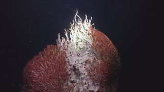
O Matterhorn, uma fonte hidrotermal na bacia do Pescadero, abriga vermes tubulares vermelhos e tapetes microbianos brancos. (Crédito da imagem: Schmidt Ocean Institute)
Sob um vulcão submarino, os cientistas descobriram um mundo oculto cheio de criaturas bizarras.
O
habitat inédito está repleto de formas de vida nunca antes vistas,
incluindo estranhas espécies de vermes, caracóis e polvos de
profundidade. O ecossistema, aninhado sob fontes hidrotermais no leste
do Pacífico, na América Central, foi encontrado quando cientistas a
bordo do navio de pesquisa Falkor usaram um braço robótico para raspar
camadas do fundo do mar.
“Em
terra, há muito tempo conhecemos animais que vivem em cavidades
subterrâneas e no oceano, animais que vivem na areia e na lama, mas pela
primeira vez, os cientistas procuraram animais sob fontes
hidrotermais”, disse Jyotika Virmani, diretor executivo do Schmidt O Ocean Institute, que liderou a expedição ao ecossistema, disse em um comunicado
. “Esta descoberta verdadeiramente notável de um novo ecossistema,
escondido sob outro ecossistema, fornece novas evidências de que a vida
existe em lugares incríveis”.
Os
cientistas descobriram as fontes hidrotermais pela primeira vez em 1977
enquanto exploravam a Cordilheira do Pacífico Leste, um limite de placa
tectônica perto das Ilhas Galápagos, na costa oeste da América do Sul.
Lá, respiradouros em forma de totens de cera derretida têm cerca de 35 a
40 pés (10 a 12 metros) de altura e jorram água quente e rica em
minerais nos oceanos.
Apesar
das temperaturas extremas em torno das aberturas - até 694 graus
Fahrenheit (368 graus Celsius) - os cientistas encontraram prósperas
cadeias alimentares cheias de bactérias quimiossintéticas, gastrópodes,
caranguejos e vermes sustentados pelos ricos nutrientes jorrando das
aberturas.
Mas até agora, nenhum cientista havia pensado em olhar sob as aberturas.
Como
parte da missão, os cientistas usaram um braço robótico para limpar um
quadrado do fundo do oceano e, em seguida, colocaram caixas de malha
sobre rachaduras na crosta terrestre. Quando os pesquisadores espiaram
dentro dessas caixas mais tarde, descobriram uma série de animais
vivendo sob as cavidades, confirmando que as criaturas chegaram lá do
fundo do mar.
Um animal, o verme tubular gigante ( Riftia pachyptila
), foi de particular interesse para os pesquisadores. Poucos dos
filhotes do animal são vistos acima das aberturas, levando os cientistas
a suspeitar que as larvas pegam carona dentro de fluidos vulcânicos
submarinos para alcançar novos habitats.
“Nossa compreensão da vida animal nas fontes hidrotermais do fundo do mar se expandiu muito com esta descoberta”, disse Monika Bright
, ecologista da Universidade de Viena que trabalhou na missão, em
comunicado. "Existem dois habitats dinâmicos de ventilação. Os animais
de ventilação acima e abaixo da superfície prosperam juntos em
uníssono, dependendo do fluido de ventilação de baixo e do oxigênio na
água do mar de cima."
“As
descobertas feitas em cada expedição do Schmidt Ocean Institute
reforçam a urgência de explorar completamente nosso oceano para que
possamos saber o que existe no fundo do mar”, disse Wendy Schmidt
, presidente e cofundadora do Schmidt Ocean Institute, em comunicado.
“A descoberta de novas criaturas, paisagens e, agora, um ecossistema
totalmente novo ressalta o quanto ainda temos a descobrir sobre o nosso
oceano – e como é importante proteger o que ainda não sabemos ou
entendemos”.
Flutuações
de longo prazo na órbita da Lua – conhecidas como oscilação lunar –
podem influenciar o crescimento do dossel de mangue. Pesquisadores na
Austrália usaram imagens de satélite de alta resolução para medir o
dossel de mangue em todo o continente entre 1987 e 2020.
Dependendo da fase de oscilação, os ecossistemas de mangue recebem
menos água – resultando em uma cobertura de dossel mais fina – ou marés
mais altas que aumentam o crescimento. Os manguezais são sumidouros
naturais de carbono, portanto, as descobertas podem ajudar a avaliar
melhor quanto carbono eles armazenarão ao longo do tempo.
Vulcões
extintos como o monte submarino Pao Pao (à direita) no sul do Oceano
Pacífico podem ajudar a subir as águas profundas, uma função crítica
para as correias transportadoras oceânicas. EXPLORAÇÃO DO OCEANO NOAA/DESCOBRINDO AS PROFUNDIDADES: EXPLORANDO MPAS REMOTOS DO PACÍFICO
Poucas forças são
tão fundamentais para o clima quanto as circulações nos oceanos do
mundo. Esses “cinturões transportadores”, como os oceanógrafos os
chamam, arrastam as águas superficiais tropicais em direção aos polos,
onde aquecem as altas latitudes antes de esfriar e afundar no abismo
quilômetros abaixo, levando consigo o calor residual e o dióxido de
carbono dissolvido. Mas a última etapa do transportador é misteriosa.
Para manter a circulação, essas águas profundas precisam voltar à
superfície – e os oceanógrafos não conseguem explicar como isso
acontece.
Agora, resultados de uma campanha do RRS Discovery ,
um navio de pesquisa do Reino Unido, parecem confirmar uma nova visão
radical de como a água do oceano profundo sobe. Suas medições de
traçadores que se elevam acima da topografia irregular do fundo do mar
sugerem que as águas profundas não brotam lentamente na maior parte do
oceano, como se pensava. Em vez disso, é desviado para cima em rajadas
concentradas pela turbulência criada por montanhas submarinas, incluindo
cordilheiras vulcânicas mesoceânicas e montes submarinos. “A forma do
fundo do mar está intimamente ligada à estrutura do oceano”, diz Trevor
McDougall, físico oceânico da Universidade de Nova Gales do Sul que
ajudou a estabelecer a estrutura teórica para a descoberta. “Esta é uma
nova maneira de olhar para o oceano profundo.”
A descoberta, relatada no início deste mês no Ocean Sciences Meeting ,
pode ter amplas implicações. As águas profundas, em vez de permanecerem
isoladas por centenas ou milhares de anos, podem retornar rapidamente –
acelerando a mudança climática ao liberar o carbono que armazenam. As
ressurgências também podem aumentar o nível do mar em alguns locais. E o
novo quadro pode forçar os oceanógrafos a repensar o comportamento dos
oceanos do passado, quando os contornos do fundo do mar diferiam dos
atuais.
Os esforços para resolver o
quebra-cabeça da ressurgência remontam a décadas, até um artigo seminal
de 1966 do famoso oceanógrafo Walter Munk intitulado “ Receitas abissais ”.
Ele propôs que as ondas internas que se formam ao longo dos limites
entre as camadas oceânicas de diferentes densidades ocasionalmente
quebram, assim como as ondas na costa. Essa turbulência, se amplamente
distribuída, pode misturar lentamente águas profundas e pesadas e
enviá-las para cima. Uma vez que atingissem um nível de 2 quilômetros
abaixo da superfície, as águas fluiriam para o Oceano Antártico, onde
ventos fortes puxavam as águas para a superfície.
Quando as sondas de queda
livre começaram a medir a turbulência do oceano profundo há várias
décadas, no entanto, descobriram que grande parte do oceano estava calmo
– calmo demais. “As pessoas saíram e procuraram para sempre e não
conseguiram encontrar [turbulência]”, diz Matthew Alford, oceanógrafo
físico da Scripps Institution of Oceanography e co-investigador da nova
campanha. A turbulência encontrada tendia a crescer com a profundidade.
Como uma colher mexendo leite no café, a água estava empurrando a água
para baixo, não para cima, diz Raffaele Ferrari, oceanógrafo físico do
Instituto de Tecnologia de Massachusetts e líder da Discovery campanha
“A mixagem estava fazendo o oposto do que Walter Munk havia previsto.” A
água estava afundando não apenas nos pólos, mas também em todo o
oceano, duas vezes mais do que se pensava anteriormente.
Em 2016, duas equipes de pesquisadores , incluindo uma liderada pela Ferrari ,
montaram uma imagem que poderia explicar como as águas profundas
subiram apesar do empurrão para baixo. Perto do fundo do mar, eles
propuseram, as ondas quebrando não poderiam mais impulsionar a água para
baixo. Em vez disso, se houvesse montanhas submarinas nas proximidades,
a turbulência levaria as águas para as encostas das montanhas,
misturando-se com as águas mais claras acima. A água pode subir até uma
profundidade de 2 quilômetros, onde a bomba do Oceano Antártico pode
assumir o controle.
A ideia encontrou ceticismo -
certamente essas grandes ressurgências teriam sido detectadas antes?
Mas os oceanógrafos fizeram poucas medições perto do fundo do mar para
testar a ideia. “É uma boa maneira de quebrar seu instrumento”, diz
Ferrari.
Sua equipe começou a preencher
a lacuna em duas visitas no ano passado ao Rockall Trough, um terreno
acidentado a noroeste da Irlanda. Os pesquisadores lançaram rastreadores
não tóxicos a 1800 metros de profundidade, na base de uma parede
denteada do desfiladeiro, e monitoraram a água com amarrações e perfis
de turbulência em queda livre. Um rastreador permitirá que os
pesquisadores documentem a evolução a longo prazo da água quando
retornarem ao Discovery no
verão. Outro corante fluorescente de curta duração poderia ser seguido
em tempo real. Ele subiu 100 metros por dia durante 3 dias. “Isso foi
muito emocionante”, diz Alford. “Você poderia observar a água subindo.”
Os resultados iniciais são
“muito legais”, diz Sarah Purkey, oceanógrafa física da Scripps, não
afiliada ao projeto. “Parece que estamos falando sobre esse dia há
muito tempo.” A taxa de ressurgência parece corresponder à teoria, diz
ela. A questão agora é se os processos neste local podem ser
extrapolados. “Como escalamos isso para todo o oceano?”
Medidas de ressurgência e turbulência, que serão publicadas em breve, de uma pesquisa realizada há 10 anos na
Passagem de Drake, um canal acidentado do fundo do mar entre o Chile e a
Antártida, concordam em princípio, diz Ali Mashayekhi, dinamicista de
fluidos ambientais do Imperial College London. “Portanto, há alguma
indicação de que o que eles estão encontrando é de importância
genérica.”
Os Discovery também
sugerem que a história não será tão simples quanto Ferrari e outros
indicaram inicialmente, diz Sonya Legg, oceanógrafa física da
Universidade de Princeton. As marés parecem influenciar os fluxos, não
apenas a turbulência. E o destino a longo prazo da água de ressurgência
continua a ser visto. É possível que tenha sido levado e dissipado por
redemoinhos oceânicos.
Mas a Ferrari está encorajada
pelos resultados e diz que eles ajudam a entender certas idiossincrasias
oceânicas. Por exemplo, o norte do Oceano Pacífico carece de muita
circulação de capotamento. Mas também tem poucos montes submarinos ou
cumes vulcânicos – e sem esses facilitadores, a água não pode subir. As
descobertas também significam que as correntes dos oceanos passados
podem ter sido fundamentalmente diferentes, dependendo da atividade
vulcânica da Terra – e do quão acidentado ela tornou o fundo do mar.
“Não é apenas uma questão de onde estão os continentes”, diz ele. “Você
também precisa conhecer a estrutura do fundo do mar.”
segunda-feira, 19 de julho de 2021
Um misterioso vulcão submarino quebrado por um submersível
Copyright ROV Team GEOMAR
Vulcão submarino surpresa pode oferecer uma janela única para o interior da Terra
Em 2015, uma equipe de pesquisa alemã enviou um submersível para o fundo do Oceano Pacífico. A
oeste do Peru, o robô montado em uma câmera explorou uma vasta extensão
do fundo do mar, com 4 quilômetros (mais de 2 milhas) de profundidade,
conhecida por sua extrema planura. “Está muito escuro”, lembra Antje Boetius, bióloga do Instituto Alfred Wegener. “Então você liga as luzes do robô e vê uma nova paisagem que ninguém nunca viu antes.”
Uma
característica em particular pegou Boetius de surpresa: uma pequena
montanha elevando-se a 300 metros do fundo do mar, suas encostas
íngremes cobertas de lava em forma de travesseiros e veios escuros
anômalos que provavelmente são depósitos de magma. A
equipe descobriu um vulcão submarino, ou monte submarino, em uma
planície abissal - uma região geologicamente inativa que não deveria ter
nenhum.
Em
um novo estudo, os cientistas sugerem que o monte submarino pode
representar um tipo completamente novo de vulcanismo do fundo do mar,
alimentado por um reservatório oculto e raso de magma. Evidências
de vulcanismo isolado como este podem ser uma janela única para o
interior da Terra, diz Adam Soule, oceanógrafo da Universidade de Rhode
Island, Narragansett Bay, e diretor do Ocean Exploration Cooperative
Institute, que não esteve envolvido no estudo.
INSCREVA-SE NO NOSSO NEWSLETTER DIÁRIO
Obtenha mais conteúdo excelente como este diretamente para você!
A maioria dos 1.500 vulcões ativos da Terra são encontrados debaixo d'água. A
grande maioria deles se forma nos limites das placas tectônicas: ou
centros de expansão do fundo do mar, onde a lava recém-erupcionada
separa as placas, ou em zonas de subducção, onde as placas mergulham uma
sob a outra, levando ao derretimento do manto abaixo que pode alimentar
erupções.
Vulcões
do fundo do mar também podem ocorrer acima de pontos quentes do manto,
plumas fixas de magma subindo das profundezas da Terra. À medida que as placas de nosso planeta passam sobre eles, as plumas levam a cadeias de vulcões, como as ilhas havaianas.
No
entanto, nenhuma dessas teorias existentes explica o novo monte
submarino, que está longe de quaisquer plumas de manto conhecidas e fica
a centenas de quilômetros dos limites da placa de Nazca, diz Colin
Devey, um vulcanologista do Geomar Helmholtz Center for Ocean Research
Kiel.
Depois
de usar o submersível para explorar o vulcão por mais de 4 horas,
Devey, Boetius e colegas mapearam o local enviando raios de sonar de seu
navio e ouvindo os ecos. A equipe encontrou uma falta de sedimento oceânico
cobrindo a lava, bem como uma curiosa falta de animais como estrelas do
mar, que costumam colonizar rapidamente as superfícies duras dos montes
submarinos, relatam na Geologia Marinha
. Os cientistas também observaram que parte da lava rompeu a crosta
mineral de crescimento lento que cobria o monte submarino. Ambas as
observações sugerem que o vulcão entrou em erupção recentemente, talvez
em algum momento nos últimos milhares de anos, destruindo a
biodiversidade que existia ali.
Ainda
assim, Kenneth Rubin, um vulcanologista da Universidade do Havaí,
Manoa, que não esteve envolvido no trabalho, diz que é “prematuro”
declarar este um vulcão jovem. Ele diz que a falta de sedimentos pode ser explicada pelas correntes do fundo do oceano que os arrastam. Outro submersível deve ser enviado, diz ele, para observar novamente o local e coletar espécimes para datá-los.
A equipe de Devey também investigou o que pode estar alimentando um vulcão no meio do nada. Usando
dados de estudos anteriores que usaram técnicas sísmicas para obter
imagens do manto superior da Terra, os pesquisadores descobriram uma
concentração excepcionalmente alta de magma a cerca de 70 quilômetros
abaixo desta parte da placa de Nazca. Os
centros de disseminação do fundo do mar geralmente contêm reservatórios
de magma em profundidades relativamente rasas, mas Devey diz que foi
surpreendente encontrar magma nesta profundidade sob uma planície
abissal.
A química do magma aqui poderia ser diferente, especula Devey, permitindo que ele derreta em uma temperatura mais baixa. Alternativamente,
ele sugere que as teorias atuais podem estar erradas sobre o quão
permeáveis as placas da planície abissal são até mesmo para pequenas
quantidades de magma, e que essas extensões poderiam ser pontilhadas com
muitos mais vulcões jovens.
Se
isso for realmente vulcanismo, as teorias tradicionais dificilmente se
aplicam e deve, de fato, ter sido formado por um desses mecanismos menos
conhecidos, Rubin diz.
Mesmo
que a origem do monte submarino permaneça um mistério, a descoberta
mostra como as planícies abissais dos oceanos, em grande parte não
mapeadas, são locais férteis para serem descobertos, acrescenta Soule. “Não estou realmente surpreso que descobertas sejam feitas nesta parte do oceano, só porque não olhamos muito para ela.”
Devey
pretende fazer mais mergulhos com submersíveis nos próximos anos para
criar um mapa detalhado da região e coletar amostras. Se tiver sorte, diz ele, pode até descobrir outro novo monte submarino. “É como encontrar uma agulha em um palheiro na primeira tentativa”, diz ele. “Mas eu me pergunto quantas agulhas estão realmente lá embaixo.”
Júlio Verne enviou seu submarino fictício, o Nautilus, ao Polo Sul através de um oceano oculto sob uma espessa calota de gelo. Escrito 40 anos antes de qualquer explorador chegar ao polo, sua história era apenas meia ficção.
De fato, existem cavidades oceânicas ocultas ao redor da Antártica, e nossas pesquisas mais recentes exploram como o oceano circula sob as prateleiras de gelo do continente - grandes extensões flutuantes de gelo em terra que sobem e caem com as marés.
Essas plataformas de gelo sustentam a enorme calota de gelo terrestre do continente e desempenham um papel importante na avaliação da futura elevação do nível do mar. Nosso trabalho lança uma nova luz sobre como as correntes oceânicas contribuem para o derretimento na Antártica, que é uma das maiores incertezas nas previsões de modelos climáticos. Read more: Climate scientists explore hidden ocean beneath Antarctica's largest ice shelf
An unexplored ocean
(Image credit: Shutterstock)A Plataforma de Gelo Ross é a maior placa flutuante de gelo da Terra, com 480.000 quilômetros quadrados. A cavidade oculta oculta se estende por 700 km ao sul da costa da Antártica e permanece praticamente inexplorada.
Sabemos que as prateleiras de gelo derretem principalmente por baixo, banhadas por um oceano em aquecimento. Mas temos muito poucos dados disponíveis sobre como a água se mistura sob o gelo. Isso geralmente é negligenciado nos modelos climáticos, mas nossas novas medidas ajudarão a corrigir isso.
A única outra expedição para a cavidade oceânica sob a plataforma central de gelo Ross remonta à década de 1970 e voltou com resultados intrigantes. Apesar da tecnologia limitada da época, mostrou que a cavidade do oceano não era uma banheira estática. Em vez disso, encontrou camadas finas de massas de água, com temperaturas e salinidades sutilmente diferentes entre as camadas.
Outros estudos oceânicos foram realizados a partir das margens ou do alto. Eles forneceram informações sobre como o sistema funciona, mas para realmente entendê-lo, precisávamos fazer medições diretamente do oceano sob centenas de metros de gelo.
Em 2017, usamos um jato de água quente, modelado em um projeto da British Antarctic Survey, para perfurar 350 metros de gelo no oceano abaixo. Conseguimos manter o líquido do buraco por tempo suficiente para fazer medições detalhadas do oceano e deixar instrumentos para trás para continuar monitorando as correntes e a temperatura do oceano. Esses dados ainda estão chegando via satélite.
Descobrimos que o oceano oculto age como um estuário maciço com água do mar comparativamente quente (2 ℃) entrando no leito do mar para pedalar perto da superfície em uma combinação de água derretida e água doce subglacial espremida da camada de gelo e da base rochosa escondida da Antártica .
As centenas de metros de gelo isolam a cavidade do oceano dos ventos furiosos e da temperatura do ar congelante da Antártica. Mas nada para as marés. Nossos dados sugerem que as marés empurram o oceano estratificado para frente e para trás, passando por ondulações na parte inferior do gelo e misturando partes da cavidade do oceano.
This
sort of discovery is the ultimate challenge for climate science. How do
we represent processes that work at daily scales in models that make
projections over centuries? Our data show the daily changes can add up,
so finding a solution matters.
For
example, data collected outside the ocean cavity and computer models
suggest that any given parcel of water spends one to six years making
its way through the cavity. Our new data indicate the lower end of the
range is more likely and that we should not be thinking in terms of one
grand circuit anyway.
The Ross is not the ice shelf in most danger from warming oceans. But its sheer size and its relationship with the neighboring Ross Sea means it is a vital cog in the planetary ocean system.
A importância dessas plataformas de gelo para o aumento do nível do mar nos próximos séculos é muito aparente. Pesquisas mostram que, se o aquecimento atmosférico exceder 2 ℃, as principais plataformas de gelo antártico entrariam em colapso e liberariam o gelo que flui da calota de gelo do continente - elevando o nível do mar em até 3 metros até 2300.
O que é menos compreendido, mas também potencialmente um agente massivo de mudança, é o impacto da água derretida na circulação termohalina global, um ciclo de transporte oceânico que vê o ciclo oceânico do abismo ao largo da costa da Antártida até as águas superficiais tropicais a cada 1.000 anos ou então.
As prateleiras de gelo da Antártica são como um pit stop nesse circuito e, portanto, o que acontece na Antártica ressoa globalmente. Prateleiras de gelo com derretimento mais rápido mudarão a estratificação do oceano, com repercussões na circulação global do oceano - e um resultado disso parece ser uma maior variabilidade climática.
sexta-feira, 26 de julho de 2019
Seabed mining is coming — bringing mineral riches and fears of epic extinctions
Plans are advancing to harvest precious ores from
the ocean floor, but scientists say that companies have not tested them
enough to avoid devastating damage.
A ghostly
sponge lives on a Pacific seamount, one of the environments targeted by
contractors interested in mining the ocean floor.Credit: Zhang Jiansong/Xinhua/Alamy
In 1972, a young ecologist named Hjalmar Thiel ventured to a
remote part of the Pacific Ocean known as the Clarion–Clipperton Zone
(CCZ). The sea floor there boasts one of the world’s largest untapped
collections of rare-earth elements. Some 4,000 metres below the ocean
surface, the abyssal ooze of the CCZ holds trillions of polymetallic
nodules — potato-sized deposits loaded with copper, nickel, manganese
and other precious ores.
Thiel was interested in the region’s
largely unstudied meiofauna — the tiny animals that live on and between
the nodules. His travel companions — prospective miners — were more
eager to harvest its riches. “We had a lot of fights,” he says. On
another voyage, Thiel visited the Red Sea with would-be miners who were
keen to extract potentially valuable ores from the region’s metal-rich
muds. At one point, he cautioned them that if they went ahead with their
plans and dumped their waste sediment at the sea surface, it could
suffocate small swimmers such as plankton. “They were nearly ready to
drown me,” Thiel recalls of his companions.
Em 1972, um jovem ecologista chamado Hjalmar Thiel se aventurou em uma parte remota do Oceano Pacífico conhecida como Zona Clarion-Clipperton (CCZ). O fundo do mar possui uma das maiores coleções inexploradas de elementos de terras raras do mundo. A cerca de 4.000 metros abaixo da superfície do oceano, o lodo abissal do CCZ contém trilhões de nódulos polimetálicos - depósitos do tamanho de uma batata carregados com cobre, níquel, manganês e outros minérios preciosos. Thiel estava interessado na meiofauna em grande parte não estudada da região - os minúsculos animais que vivem entre os nódulos. Seus companheiros de viagem - mineiros em potencial - estavam mais ansiosos para colher suas riquezas. "Tivemos muitas lutas", diz ele. Em outra viagem, Thiel visitou o Mar Vermelho com pretensos mineradores que queriam extrair minérios potencialmente valiosos das lamas ricas em metais da região. Em determinado momento, ele alertou que, se fossem adiante com seus planos e jogassem seus sedimentos na superfície do mar, poderiam sufocar pequenos nadadores, como o plâncton. "Eles estavam quase prontos para me afogar", lembra Thiel de seus companheiros.
In a later
confrontation, Thiel — who was at the University of Hamburg in Germany —
questioned how industry planned to test the environmental impacts of
sea-bed mining. He was curtly advised to do his own test. So he did, in
1989.
Thirty years on, the test that Thiel and a colleague devised
is still the largest experiment ever on the potential impacts of
commercial deep-sea mining. Called DISCOL, the simple trial involved
raking the centre of a roughly 11-square-kilometre plot in the Pacific
Ocean with an 8-metre-wide implement called a plough harrow. The
simulated mining created a plume of disturbed sediment that rained down
and buried most of the study area, smothering creatures on the sea
floor. The test revealed that the impacts of sea-bed mining reached
further than anyone had imagined, but it did not actually extract any
rocks from the sea bed, which itself would have destroyed even more
marine life.
There have been many attempts to advance DISCOL’s
basic approach, but none has succeeded, mostly owing to technical and
financial difficulties. The most recently planned mining trial, to test a robotic nodule harvester in the CCZ
this April, was called off at the last minute because of a technical
failure. The trial, planned by the Belgian contractor Global Sea Mineral
Resources, would have given scientists a better grasp of the impacts of
sea-bed mining by using a 25-tonne tractor to plough the ocean floor.
Manganese nodules cover the sea floor in the Clarion–Clipperton Zone.Credit: ROV KIEL 6000, GEOMAR (CC BY 4.0)
“This was definitely a significant setback, because it was
really the only opportunity to try to even start to see the interaction
of these big, heavy machines with the marine environment,” says Kristina
Gjerde, a high-seas policy adviser with the International Union for
Conservation of Nature in Cambridge, Massachusetts.
Such has been
the troubled trajectory of deep-sea mining ever since eager
industrialists proved, nearly a half century ago, that it was
technically feasible to extract rare metals and minerals from the ocean
floor. Companies and nations have often promised that they would soon
start pulling valuable ores from the depths, but commercial efforts have
failed to take off for a variety of reasons — notably huge up-front
costs, the historically low value of deep-sea ores and the lack of
regulations, which have contributed to investors’ wariness.
“The
technology is available — it’s the financial and regulatory uncertainty
that has held the industry back,” says Govinder Singh Chopra, founder of
SeaTech in Singapore, a designer of deep-sea mining support vessels.
Now,
it seems this nascent industry’s time has come. A growing demand for
batteries to power electric cars and to store wind and solar energy has
driven up the cost of many rare-earth metals and bolstered the business
case for sea-bed mining. What’s more, the industry’s long-awaited
regulations — in the form of a mining code — are due to be finalized by
2020, putting in place a process whereby contractors can apply for
30-year licences to mine assigned ‘claim areas’ in parts of the
international sea bed such as the CCZ. Already, miners are exploring the
potential wealth of these claim areas, but no commercial extraction
will begin until the regulations are in place. Investments in this
industry are now growing.
Last month, a start-up called DeepGreen
in Vancouver, Canada, announced that it is raising US$150 million to
begin exploring mineral wealth in part of the Pacific Ocean — a sign of
growing confidence in the industry’s future.
Both scientists and
conservationists, however, are worried that the creation of regulations
will encourage the industry to start mining long before there is enough
information on how operators can avoid causing serious environmental
harm. The scarce data that exist suggest that deep-sea mining will have
devastating, and potentially irreversible, impacts on marine life.
Deep sea
animals collected from abyssal ocean floor in Clarion-Clipperton Zone.
Clockwise from top left: Sea cucumber known as the ‘gummy squirrel’ (Psychropotes longicauda), a sea urchin and two sea cucumbers.Credit: DeepCCZ Project
Since the DISCOL experiment was completed, scientists have
returned to the site four times, most recently in 2015. The site has
never recovered. In the ploughed areas, which remain as visible today as
they were 30 years ago, there’s been little return of characteristic
animals such as sponges, soft corals and sea anemones. “The disturbance
is much stronger and lasting much longer than we ever would have
thought,” says Thiel.
The quiet place
The deep sea —
usually defined as the realm below 200 metres — is a world of extremes.
Temperatures near the sea bed in many places hover near 0 °C, there is
next to no light, and pressures can exceed 1,000 bars, equivalent to
having a couple of elephants standing on your big toe. But still life
thrives. The deep sea contains a vast array of ecosystems that
researchers have barely begun to study.
Miners have focused on three environment types to explore for potential harvesting. Abyssal plains such as the CCZ
are littered with metallic nodules that form over millions of years as
minerals precipitate around fish teeth, bones or other small objects.
These regions are some of the quietest, most remote ecosystems on the
planet, where fine sediment rains down at a rate of about one centimetre
every 1,000 years. That low-energy environment is home to polychaete
worms, crustaceans, sponges, sea cucumbers, starfish, brittlestars, sea
urchins and various deep-sea fish, as well as countless microbial
species and tiny sediment-dwelling creatures.
Another type of
mineral deposit is the metal-rich crust that covers seamounts, which
rise thousands of metres above the abyssal plains. These coatings are
packed with high-value metals, such as cobalt, platinum and molybdenum.
The seamount environment is dominated by corals, sponges and other
filter feeders as well as tuna, sharks, dolphins and sea turtles.
Deep sea
creatures found near a mid-ocean ridge in the southern Indian Ocean.
Clockwise from top left: an anemone, a brittle star, Acanthogorgiidae coral and a pencil urchin.Credit: Nature Picture Library/Alamy
A third form of mineral deposit that is attracting attention
is massive sulfides — rich in copper, lead, zinc, gold and silver.
These ores form around vents of superheated water that occur along the
volcanic ridges running through ocean basins. The hydrothermal vents
support creatures such as the small, blind yeti crab (Kiwa tyleri) with its characteristic blonde, furry hair, and the scaly-foot snail (Chrysomallon squamiferum), which armours its soft interior with an iron shell and is the first deep-sea animal to be declared endangered because of the threat of mining.
For
years, it was assumed that the first deep-sea environment to be mined
would be hydrothermal vents in Papua New Guinea’s territorial waters.
Nautilus Minerals in Toronto, Canada, was pursuing that project, but
financial difficulties and local opposition derailed the venture,
leaving the CCZ as the most likely test bed for deep-sea mining.
Estimates suggest that the nodules in that region contain more cobalt,
manganese and nickel than the total of all known deposits on land (see
‘Sunken treasure’). The CCZ stretches from Hawaii to the Baja California
Peninsula, and is as wide as the contiguous United States.
Sources: Map: M. Hannigton et al. Nature Geosci. 10, 158–159 (2017); Data: J. R. Hein et al. Ore Geol. Rev. 51, 1–14 (2013)
Companies are steadily moving forward with plans to exploit
the minerals in the CCZ. The International Seabed Authority (ISA) — a
168-member body created by the United Nations to both promote and
regulate sea-bed mining — has, in the past decade, granted 29
exploration licences for contractors sponsored by national governments
to explore mineral wealth at a number of deep-sea locations. Of the
licences granted, 16 are for the CCZ, and these cover about 20% of the
total area.
Since Thiel’s first visit to the region in 1972,
scientists have explored it in much more detail. Deep-sea biologist
Craig Smith at the University of Hawaii in Honolulu has spent 30 years
studying the communities in the CCZ, where he has collected sea
cucumbers, sea urchins, soft corals, starfish, sea anemones, worms and
much more. Roughly 90% of the animal species his group has collected are
new to science or undescribed. Among these are rare species not found
anywhere else in the deep sea, including gummy squirrels (Psychropotes longicauda)
— a type of ‘red-lipped’ sea cucumber — and worms that resemble squid.
Smith thinks that, even now, scientists have sampled just 0.01% of the
total area of the CCZ.
In one single UK claim area of 55,000
square kilometres, Smith and his colleagues were surprised to collect
more than 1,000 animal species, which they estimate is less than half
the total number living there. “And that’s not counting the microbes, of
which there are over 100,000 different species,” says Smith. “We expect
that there are thousands of species that are unique to the CCZ,” he
says. “I’ve been studying biodiversity there for decades, but we still
don’t know that much.” Some of the species could have small ranges, so
if they were to be wiped out, it would be a global extinction.
Data gaps
Although
deep-sea mining threatens some of these species, it has also raised
awareness of the biodiversity of the sea-floor environment. By law,
mining contractors are required to assess what lives in their claim
area, and Smith and many other deep-sea biologists conduct ecological
surveys to help contractors establish this baseline. And prospective
miners can carry out tests to understand how their equipment will impact
the environment they are working in.
A blind yeti crab (Kiwa tyleri) from a hydrothermal vent area in the southern Indian Ocean.Credit: David Shale/Nature Picture Library
The aim of such studies is to help miners and the ISA reduce
any potential harm from the industry and to develop environmental
management plans. But many researchers say that the system has not
worked well in practice, in part because the requirements for baseline
data are weak.
The data have been confidential, but are becoming
publicly available this month. “It’s going to be quite telling because
we’ll have an insight for the first time into the quality and quantity
of contractor data. My guess is that many contractors are not putting
together what we would regard as a thorough baseline assessment,” says
Daniel Jones, a deep-sea ecologist at the National Oceanography Centre
in Southampton, UK.
Another concern among researchers is that
there are no requirements to test the environmental impacts of the giant
mining machines before commercial extraction begins. Since 1970, only
12 small-scale tests have been done on nodule mining, most using a
narrow, roughly 2.5-metre-wide instrument to disturb the sea floor. Of
these, DISCOL is regarded as the most advanced, mostly because of the
wider plough, the large area covered and the long time series of data.
“All of these studies have flaws, and DISCOL, too, is imperfect, but
it’s the best we have,” says Jones.
Many scientists and
conservationists say that the root of some of the problems is that the
ISA has dual responsibilities. When it was established by the UN in
1994, the ISA was given two mandates: to protect the international sea
bed from serious harm, and to develop its resources, ensuring that their
exploitation benefits humankind. (In national waters, countries can
develop their own rules around sea-bed mining, but they must be at least
at strict as the rules that will be adopted next year by the ISA). The
“ISA is both poacher and gamekeeper”, says Hannah Lily, a maritime
lawyer with the Pew Charitable Trusts in London, who is not speaking on
behalf of Pew.
The ISA has responded to some of these concerns. It
says that “an extremely important aspect of ISA’s mandate is ensuring
appropriate environmental assessments and safeguards in the activities
that it regulates”, for instance.
It also says that “its decisions
are made by consensus among the 168 countries that make up its
membership, all countries having one vote”. So far, the membership has
approved only exploration activities.
The Belgian contractor
Global Sea Mineral Resources has defended how mining contractors and the
ISA are moving forward. It says that the ISA has been proactive in
establishing an environmental management plan that includes setting
aside nine areas of particular environmental interest. The intention is
keep these areas — about 30% of the CCZ — free of mining to protect
biodiversity.
Smothered by sediment
Mining in the CCZ, if
it does happen, is still almost a decade away, with Global Sea Mineral
Resources aiming to open a commercial deep-sea mine by 2027. When it
does kick off, the scene at the ocean bottom will look something like
this: robotic machines as large as combine harvesters will crawl along,
picking up metallic nodules and sucking up the top 10 centimetres or so
of soft sediment with them. Because the nodules grow so slowly, mining
them will effectively remove them from the sea floor permanently, say
scientists.
The nodules are an irreplaceable habitat for many of
the creatures that live in the CCZ. “For most of the animals in the
direct vicinity, mining will be lethal. It will wipe out most of the
large animals and everything that’s attached to the nodules. That’s a
given, I would say,” says Henko de Stigter, an ocean-systems scientist
at the Royal Netherlands Institute for Sea Research in Texel, whose
assessment is shared by many researchers.
But the impacts of
mining in the CCZ would be much broader than just killing the ecosystem
around the nodules. As the collectors moved across the sea floor, they
would stir up large clouds of soft sediment that would disperse,
possibly for tens of thousands of kilometres, before eventually
resettling. At high densities, sediment plumes can bury and smother the
animals on the sea floor. Just how far the sediment will disperse
remains unknown. “We’re only starting to see how far the plume reaches
and we’re still very far from knowing what the effect will be,” says de
Stigter. Next month, he will test the impacts of a prototype nodule
harvester in shallow Mediterranean waters.
Scientists are also
carrying out laboratory and computer simulations to assess the impact of
the disturbed sediment. One computer-modelling study, published in
January (B. Gillard et al. Elem. Sci. Anth.7, 5; 2019),
found that the sediment could take up to ten times longer to resettle
than is currently assumed, meaning it will probably travel farther in
the water column. And some researchers say that even trace amounts of
sediment stirred up by the mining operations could smother sea-floor
life far away.
In the CCZ, once the nodules have been collected by
a harvester, they’ll be shunted up a kilometres-long tube to a large
surface support vessel, which will sort out millions of nodules a day
and return the waste sediment to the sea, creating yet another plume.
Right now, there’s little clarity on where the waste will be released,
in part because returning sediments to the sea bed is costly and
technically challenging. One suggestion is to reinject the plume at a
depth of 1,000 metres, still thousands of metres above the sea bed.
Scientists worry that this practice could harm or kill life at mid-water
depths, just as Thiel feared 30 years ago.
Without more
information about these deep-sea environments, researchers don’t even
know how to define the risks. “What is serious harm? There are some
clear red lines, but there’s no definitive answer to that question yet,”
says Gordon Paterson, one of three ecologists who sit on the ISA’s
Legal and Technical Commission (LTC), which is, in part, a scientific
advisory body. “We understand that global extinction is serious harm and
we know that interference in carbon sequestration is serious harm.
Scientists know that mining will cause local extinction of species in
the CCZ, but are we talking about the extinction of species across the
CCZ or just in the mined area? It is complicated,” he says.
In the North Pacific Ocean, a remotely operated vehicle collects a metallic nodule with a deep-sea creature growing on top.Credit: GEOMAR (CC BY 4.0)
How to start an industry
Amid this dearth of data,
the ISA is pushing to finish its regulations next year. Its council met
this month in Kingston, Jamaica, to work through a draft of the mining
code, which covers all aspects — environmental, administrative and
financial — of how the industry will operate. The ISA says that it is
listening to scientists and incorporating their advice as it develops
the regulations. “This is the most preparation that we’ve ever done for
any industrial activity,” says Michael Lodge, the ISA’s
secretary-general, who sees the mining code as giving general guidance,
with room to develop more progressive standards over time.
And
many scientists agree. “This is much better than we have acted in the
past on oil and gas production, deforestation or disposal of nuclear
waste,” says Matthias Haeckel, a biogeochemist at the GEOMAR Helmholtz
Centre for Ocean Research Kiel in Germany.
The ISA has been
criticized by some researchers for seeking expert advice only from the
three LTC ecologists. But Cindy Van Dover, a deep-sea biologist at Duke
University in Durham, North Carolina, says that the ISA receives a lot
of free help from scientists such as herself. “There’s a lot of
behind-the-scenes science that’s being fed into ISA,” she says.
Another
charge levelled at the ISA is that it is not transparent about how it
makes decisions; the meetings of the organization’s legal and technical
commission, for example, are closed, and the summary reports lack
detail, say Gjerde and Jones. In particular, many are upset that
scientists aren’t consulted more in the granting of exploration
licences. Last year, for example, Poland was awarded the right to
explore 10,000 square kilometres of the Mid-Atlantic Ridge for mining.
The claim area is adjacent to the Lost City, a unique hydrothermal field
that has been earmarked by the United Nations Educational, Scientific
and Cultural Organization for World Heritage Site status. Both
scientists and conservationists have objected to this decision. Among
the critics is Gretchen Früh-Green, a biologist at the Swiss Federal
Institute of Technology in Zurich, who was part of the team that
discovered the Lost City in 2000.
It’s also clear that many would
like the industry to find a better way of judging the harm deep-sea
mining might cause before commercial extraction begins. “As the inventor
of DISCOL, I would say we need a better experiment,” says Thiel. But
contractors say it would be prohibitively expensive to carry out a
full-scale mining trial.
The ISA sees an advantage in moving
forward. “Once you have mining, you have monitoring, then you can
develop standards and you can progressively tighten those standards once
you have a feedback loop from monitoring your activity,” says Lodge.
Not
everyone is convinced that this wait-and-see approach will work. “If
industry proceeds so far, if they invest money, they will want a certain
security that they can do the mining. So monitoring the mining test
will not change much,” says Thiel. Jones agrees. “The regulations are
quite hard to amend once they are put in place,” he says. “It would
require the agreement of many nations that only meet infrequently”.
For
the moment, the ISA has the tough job of getting its 168 member nations
to even agree on the draft code, which conservationists and scientists
hope will mandate industry to behave responsibly. After that, it will
take several years for mining companies to raise money for their
ventures and to build and test equipment. Given those constraints,
there’s still an opportunity for scientists to improve how they gauge
the risks of harvesting minerals from the sea floor. “You can’t just
stick your head in the sand,” says Van Dover, “and hope it will all go
away.”
Nature571, 465-468 (2019)
doi: 10.1038/d41586-019-02242-y
segunda-feira, 15 de outubro de 2018
Mariana Trench: The Deepest Depths
By Becky Oskin, Contributing Writer |
This image of the Challenger
Deep in the Mariana Trench, the deepest spot on Earth, was made using
sound waves bounched off the sea floor. Darker blues represent deeper
spots.
Credit: NASA/UNH Center for Coastal and Ocean Mapping/Joint Hydrographic Center
The Mariana Trench is a crescent-shaped trench in the Western Pacific,
just east of the Mariana Islands near Guam. The region surrounding the
trench is noteworthy for many unique environments. The Mariana Trench
contains the deepest known points on Earth, vents bubbling up liquid
sulfur and carbon dioxide, active mud volcanoes and marine life adapted
to pressures 1,000 times that at sea level.
The Challenger Deep, in the southern end of the Mariana Trench
(sometimes called the Marianas Trench), is the deepest spot in the
ocean. Its depth is difficult to measure from the surface, but modern
estimates vary by less than 1,000 feet (305 meters).
In 2010, the Challenger Deep was pegged at 36,070 feet (10,994 m), as
measured with sounds pulses sent through the ocean during a 2010 survey
by the National Oceanic and Atmospheric Administration (NOAA).
In 2012, film director and deep-sea explorer James Cameron descended to
the bottom of Challenger Deep, briefly reaching 35,756 feet (10,898 m)
during the 2012 expedition. But he could have gone a little deeper. A high-resolution seafloor mapping survey
published in 2014 by researchers from the University of New Hampshire
said the Challenger Deep bottoms out at 36,037 feet (10,984 m).
The ocean's second-deepest place is also in the Mariana Trench. The
Sirena Deep, which lies 124 miles (200 kilometers) to the east of
Challenger Deep, is a bruising 35,462 feet deep (10,809 m).
By comparison, Mount Everest
stands at 29,026 feet (8,848 m) above sea level, meaning the deepest
part of the Mariana Trench is 7,044 feet (2,147 m) deeper than Everest
is tall.
Protected land
The Mariana Trench is 1,580 miles (2,542 kilometers) long — more than
five times the length of the Grand Canyon. However, the narrow trench
averages only 43 miles (69 km) wide.
Because Guam is a U.S. territory and the 15 Northern Mariana Islands
are a U.S. Commonwealth, the United States has jurisdiction over the
Mariana Trench. In 2009, President George W. Bush established the
Mariana Trench Marine National Monument, which created a protected marine reserve
for the approximately 195,000 square miles (506,000 square km) of
seafloor and waters surrounding the remote islands. It includes most of
the Mariana Trench, 21 underwater volcanoes and areas around three
islands.
How the trench formed
The Mariana Trench was created by the process that occurs in a subduction zone,
where two massive slabs of oceanic crust collide. At a subduction zone,
one piece of oceanic crust is pushed and pulled underneath the other,
sinking into the Earth's mantle, the layer under the crust. Where the
two pieces of crust intersect, a deep trench forms above the bend in the
sinking crust. In this case, the Pacific Ocean crust is bending below
the Philippine crust. [Infographic: Tallest Mountain to Deepest Ocean Trench]
The Pacific crust, also called a tectonic plate, is about 180 million
years old where it dives into the trench. The Philippine plate is
younger and smaller than the Pacific plate.
"At subduction zones, the cold, dense crust sinks back into the mantle
and is destroyed," said Nicholas van der Elst, a seismologist at
Columbia University's Lamont Doherty Earth Observatory in Palisades, New
York.
As deep as the trench is, it is not the spot closest to the center of
Earth. Because the planet bulges at the equator, the radius at the poles
is about 16 miles (25 km) less than the radius at the equator. So,
parts of the Arctic Ocean seabed are closer to the Earth's center than
the Challenger Deep.
The crushing water pressure on the floor of the trench is more than 8
tons per square inch (703 kilograms per square meter). This is more than
1,000 times the pressure felt at sea level, or the equivalent of having
50 jumbo jets piled on top of a person.
The Mariana Trench is located in the western Pacific Ocean.
A chain of volcanoes that rise above the ocean waves to form the
Mariana Islands mirrors the crescent-shaped arc of the Mariana Trench.
Interspersed with the islands are many strange undersea volcanoes.
For example, the Eifuku submarine volcano spews liquid carbon dioxide
from hydrothermal vents similar to chimneys. The liquid coming out of
these chimneys is 217 degrees Fahrenheit (103 degrees Celsius). At the
Daikoku submarine volcano, scientists discovered a pool of molten sulfur
1,345 feet (410 m) below the ocean surface, something seen nowhere else
on Earth.
Life in the trench
Recent scientific expeditions have discovered surprisingly diverse life
in these harsh conditions. Animals living in the deepest parts of the
Mariana Trench survive in complete darkness and extreme pressure, said
Natasha Gallo, a doctoral student at the Scripps Institution of
Oceanography who has been studying the video footage from Cameron's 2012
expedition.
Food in the Mariana Trench is extremely limited,
because the deep gorge is far from land. Leaves, coconuts and trees
rarely find their way into the bottom of the trench, Gallo said, and
dead plankton sinking from the surface must drop thousands of feet to
reach Challenger Deep. Instead, some microbes rely on chemicals, such as
methane or sulfur, while other creatures gobble marine life lower on
the food chain.
The three most common organisms at the bottom of the Mariana Trench are
xenophyophores, amphipods and small sea cucumbers (holothurians), Gallo
said.
The single-celled xenophyophores resemble giant amoebas, and they eat
by surrounding and absorbing their food. Amphipods are shiny, shrimplike
scavengers commonly found in deep-sea trenches. The holothurians may be
a new species of bizarre, translucent sea cucumber.
"These are some of the deepest holothurians ever observed, and they were relatively abundant," Gallo said.
Scientists have also identified more than 200 different microorganisms
in mud collected from the Challenger Deep. The mud was brought back to
labs on dry land in special canisters, and is painstakingly kept in
conditions that mimic the crushing cold and pressure. [Video: Dive Deep: Virtual Tour of the Mariana Trench]
During Cameron's 2012 expedition, scientists also spotted microbial
mats in the Sirena Deep, the zone east of the Challenger Deep. These
clumps of microbes feed on hydrogen and methane released by chemical
reactions between seawater and rocks.
However, a deceptively vulnerable-looking fish is not only right at
home here, it's also one of the region's top predators. In 2017,
scientists reported they had collected specimens of an unusual creature,
dubbed the Mariana snailfish,
which lives at a depth of about 26,200 feet (8,000 m). The snailfish's
small, pink and scaleless body hardly seems capable of surviving in such
a punishing environment, but this fish is full of surprises,
researchers reported in a new study. The animal appears to dominate in
this ecosystem, going deeper than any other fish and exploiting the
absence of competitors by gobbling up the plentiful invertebrate prey
that inhabit the trench, the study authors wrote.
Pollution in the deep
Unfortunately, the deep ocean acts as a potential sink for discarded
pollutants and litter. In a recent study, a research team led by
Newcastle University shows that human-made chemicals that were banned in
the 1970s are still lurking in the deepest parts of the ocean.
While sampling amphipods (shrimp-like crustaceans) from the Mariana and
Kermadec trenches, the researchers discovered extremely high levels of
persistent organic pollutants (POPs) in the organisms’ fatty tissues.
These included polychlorinated biphenyls (PCBs) and polybrominated
diphenyl ethers (PBDEs), chemicals commonly used as electrical
insulators and flame retardants, according to a study published in the
journal Nature Ecology & Evolution. These POPs were released into
the environment through industrial accidents and landfill leakages from
the 1930s until the 1970s when they were finally banned.
"We still think of the deep ocean as being this remote and pristine
realm, safe from human impact, but our research shows that, sadly, this
could not be further from the truth,” said lead author Alan Jamieson of Newcastle University in a press release.
In fact, the amphipods in the study contained levels of contamination
similar to that found in Suruga Bay, one of the most polluted industrial
zones of the northwest Pacific.
Since POPs cannot degrade naturally, they persist in the environment
for decades, reaching the bottom of the ocean by way of contaminated
plastic debris and dead animals. The pollutants are then carried from
creature to creature through the ocean’s food chain, eventually
resulting in chemical concentrations far higher than surface level
pollutions.
"The fact that we found such extraordinary levels of these pollutants
in one of the most remote and inaccessible habitats on earth really
brings home the long term, devastating impact that humankind is having
on the planet," said Jamieson in the press release.
The researchers say the next step will be to understand the
consequences of this contamination and what it is doing to the ecosystem
as a whole.
Humans and the trench
In 1875, the trench was discovered by the HMS Challenger using
recently invented sounding equipment during a global circumnavigation.
In 1951, the trench was sounded again by HMS Challenger II. Challenger Deep was named after the two vessels.
In 1960, a "deep boat" named Bathyscaphe Trieste reached the bottom of
Challenger Deep. It was the first vessel to do so and was manned by
U.S. Navy Lt. Don Walsh and Swiss scientist Jacques Piccard.
In 1995, the Japanese unmanned submarine Kaiko gathered samples and useful data from the trench.
In 2009, the United States sent a hybrid remotely operated vehicle,
Nereus, to the floor of Challenger Deep. The vehicle remained on the
seabed for nearly 10 hours.
In 2012, Cameron manned the Deepsea Challenger and reached the seabed
but was unable to capture any photos due to a hydraulic fluid leak. The
submersible was later donated to the Woods Hole Oceanographic Institution.
Plastic trash is now so pervasive, it has even made its way to the deepest part of the ocean, National Geographic reports.
Scientists found a plastic bag almost 11 kilometers deep in the Mariana
Trench in the Pacific Ocean while combing through a database of
photos from thousands of submersible dives made over the past 30
years. One-third of all debris in the database, created to provide a
record of trash in the ocean depths, were plastics, mostly single-use
products. In some photos, deep-sea creatures like sea anemones were
entangled in the plastic. Writing in Marine Policy, the researchers say the production of plastic waste needs to be drastically reduced to protect the deep-sea environment.
O lixo de plástico agora é tão difundido que chegou até a parte mais profunda do oceano, segundo a National Geographic. Os cientistas encontraram uma sacola plástica de quase 11 quilômetros de profundidade na Fossa das Marianas, no Oceano Pacífico, enquanto vasculhava um banco de dados de fotos de milhares de mergulhos submersíveis feitos nos últimos 30 anos. Um terço de todos os detritos no banco de dados, criados para fornecer um registro de lixo nas profundezas do oceano, eram plásticos, a maioria produtos de uso único. Em algumas fotos, criaturas do fundo do mar, como anêmonas do mar, estavam enredadas no plástico. Escrevendo em Política Marinha, os pesquisadores dizem que a produção de resíduos plásticos precisa ser drasticamente reduzida para proteger o ambiente do fundo do mar.
domingo, 27 de março de 2016
Por que a cor do mar varia tanto?
Por: Marcus V. Cabral
A cor depende de quais sedimentos, detritos e organismos vivos estão
dissolvidos na água. Fatores como a areia das praias também influenciam.
"Se a areia for clara, acaba refletindo mais a luz do Sol, causando a
impressão de que a água é mais clara no raso do que em áreas mais
profundas", diz Flávia Saldanha-Corrêa, bióloga e pesquisadora do
Instituto Oceanográfico da USP.
Tom sobre tom Micro-organismos e sedimentos dão diferentes cores ao oceano Azul
Devido a características físicas próprias de suas moléculas, a água
absorve mais as cores com comprimento de onda maior, como o vermelho e o
laranja. Por isso, ao receber a luz do Sol, ela reflete mais o azul,
que, próximo ao violeta, é uma das cores com menor comprimento de onda
do espectro de luz visível a nossos olhos
Verde
O tom esverdeado pode ser fruto da presença de muita matéria orgânica
dissolvida ou do fitoplâncton, conjunto de algas microscópicas que vivem
dispersas na água e constituem a base da cadeia alimentar marítima.
Esses organismos possuem clorofila, o pigmento responsável pela
fotossíntese, que apresenta cor verde
Marrom
Essa cor é comum em áreas próximas à desembocadura de rios, em que há
uma grande quantidade de sedimentos minerais ricos em ferro, que dão uma
cor lamacenta. Esses sedimentos se desprendem das rochas quando elas
são lavadas pela água e, ao se acumularem no mar, acabam dando à água
vários tons de marrom
Preto
Comum em mangues, a água preta ocorre pela presença abundante de ácido
húmico, resultado da biodegradação de outros materiais orgânicos, como
vegetais e animais. O mar Negro, no sudeste da Europa, também tem água
de coloração escura - a explicação está no excesso de sedimentos
minerais com coloração escura
Vermelho
Organismos do plâncton, como algumas cianobactérias, o dinoflagelado
Gymnodinium sanguineum e o ciliado Mesodinium rubrum, têm um pigmento
chamado ficoeritrina. Em grande densidade, esses organismos podem deixar
a água avermelhada. Provavelmente, o mar Vermelho recebeu esse nome por
causa desse fenômen
sábado, 12 de setembro de 2015
O papo dos cachalotes
Vocalizações desta espécie de cetáceos têm muito em comum
com a linguagem humana. Cada clã de cachalotes tem um repertório
próprio, usado para reconhecer outros membros do grupo.
Por: Salvatore Siciliano
Publicado em 12/09/2015
|
Atualizado em 12/09/2015
Os cachalotes se organizam em clãs que podem ser
diferenciados pelo 'dialeto' que seus membros usam para se comunicar.
(foto: Mauricio Cantor, Whitehead Lab, Dalhousie University, Canadá.
Imagine que, neste mês de setembro, teremos um grande festival de
rock na cidade do Rio de Janeiro. Milhares de pessoas, com idades entre
18 e 60 anos, virão assistir a dezenas de shows de música por vários
dias. O que motiva essas pessoas a assistirem aos shows e o que elas têm
em comum umas com as outras? E mais: o que isso tem de semelhante com a
vida social dos cachalotes?
Antes de falarmos dos cachalotes propriamente, vamos entender três
conceitos em estudos sociais: homofilia, conformismo e marcação
simbólica. Homofilia é um princípio das redes sociais, e diz que
tendemos a ser semelhantes aos nossos amigos. Já o conformismo resulta
do fato de uma pessoa mudar o seu comportamento ou as suas atitudes por
efeito da pressão do grupo – é, portanto, uma forma de interação, um
processo de influência inerente ao funcionamento dos grupos. Por fim, a
marcação simbólica implica o conceito de semelhança: ser igual dentro do
grupo e diferente das pessoas dos demais grupos.
De volta aos cachalotes, algumas informações básicas. Eles podem
viver mais de 60 anos. Os machos alcançam a maturidade sexual entre 18 e
21 anos, com 11 a 12 metros de comprimento; as fêmeas, entre 7 a 13
anos e 8,3 a 9,2 metros de comprimento. Percebeu alguma semelhança com
as sociedades humanas? É por aí mesmo. Sua estrutura social – como a de
muitos primatas – está baseada em grupos matrilineares de fêmeas
aparentadas e jovens, que frequentemente formam associações temporárias
com outras fêmeas nas regiões tropicais. Enquanto isso, os machos ficam
em águas da Antártica e do Ártico, alimentando-se das enormes lulas por
lá encontradas. De vez em quando, eles vêm até as regiões tropicais para
acasalar com as fêmeas maduras.
O que chama muito a atenção nesses grupos de fêmeas é o altruísmo
entre elas, por exemplo, no cuidado quando algum membro do grupo está
ferido ou no carinho com os bebês cachalotes – existem verdadeiras babás
que tomam conta das crias enquanto as mamães estão mergulhando fundo
para buscar lulas nas profundezas. Para se ter ideia da dimensão desses
grupos, estudos que usaram foto-identificação dos cachalotes dos Açores
(veja artigo na CH 150) mostraram que, ao redor das ilhas portuguesas, existem entre 300 e 800 fêmeas e jovens cachalotes.
Um detalhe que chama
atenção nessa estrutura social dos cachalotes é que as fêmeas cooperam
muito entre si, cuidando umas das outras quando uma delas se fere e até
atuando como babás dos filhotes enquanto as mães mergulham fundo para
buscar alimentos. (foto: Gabriel Barathieu / Wikimedia Commons / CC
BY-SA 2.0)
Nessas regiões, formam-se clãs que funcionam como unidades sociais
que compartilham um repertório de vocalizações chamadas de codas. As
codas são, na prática, a forma de linguagem entre os membros do grupo,
ou seja, a maneira como eles se reconhecem e compartilham experiências.
Dessa forma, é possível crer que os cachalotes dos Açores e das
Galápagos, por exemplo, apresentam repertórios de vocalização bem
diferentes. Assim, comparações entre as codas gravadas em diferentes
áreas, mesmo que próximas, podem revelar quantos clãs existem e como
eles interagem ente si. Diferentes formas de explorar o ambiente
submarino e seus recursos podem ajudar a moldar esses clãs, que formam
repertórios vocais diferentes (os repertórios de codas), que parecem ser
transmitidos por meio de aprendizado social.
Linguagem aprendida
Um artigo publicado na Nature Communications desta semana
avaliou 18 anos de gravações das codas dos cachalotes do Pacífico
Norte, próximo às ilhas Galápagos, e mostrou níveis complexos de
transmissão de informação das codas. A transmissão do repertório vocal
pode se dar tanto por fatores genéticos como sociais, utilizando, no
segundo caso, mecanismos tão complexos quanto os observados em culturas
humanas.
A transmissão do repertório vocal pode se dar tanto por fatores
genéticos como sociais, utilizando, no segundo caso, mecanismos tão
complexos quanto os observados em culturas humanas.
Agrupamentos distintos de cachalotes com repertórios acústicos
semelhantes, mirando-se em clãs escolhidos, surgem quando as baleias
aprendem preferencialmente as codas mais comuns (conformismo) de
indivíduos com comportamentos similares (homofilia).
Parece complexo, mas é exatamente como nós humanos agimos: falamos as
gírias que nossos colegas de classe ou profissão usam, e assim passamos
a ser mais facilmente aceitos no grupo. Usamos roupas mais parecidas
com os outros indivíduos da nossa classe social e, dessa forma, somos
mais facilmente identificados e passamos a trocar ideias e atitudes. Se
nos reunimos para um grande show de rock no Rio, ali nos juntamos a
outras pessoas que gostam desse tipo de música, de uma determinada
banda, do seu estilo de falar e de se comportar socialmente. Cachalotes e
humanos têm muita coisa em comum!
Notas
Cachalotes no Brasil O mar do Brasil está
cheio de cachalotes, mas não sabemos ainda quantificá-los ou identificar
sua estrutura social. Carecemos de estudos tão complexos quanto este
publicado na Nature. No entanto, sabemos que os cachalotes
estão por toda nossa costa pelos encalhes frequentes e por avistagens
realizadas pelos poucos programas de estudos disponíveis. Em 2001, um grande levantamento
desses registros foi publicado, e procurou-se avaliar a idade dos que
encalharam. Já tivemos até um encalhe em massa de 33 cachalotes no Rio
Grande do Sul em dezembro de 1972! As conclusões do estudo citado
apontam para uma provável sazonalidade do nascimento de filhotes no
verão e outono. Outro resultado interessante sugere uma provável
diferenciação da estrutura de crescimento dos nossos cachalotes quando
comparada a outros estudos pelo mundo, o que implica na composição
diferenciada do nosso estoque de cachalotes.
Moby Dick existiu? Coincidências
à parte, no mês de agosto passado um helicóptero flagrou um cachalote
na região de Toulon, no Mediterrâneo, ao sul da França, que fez crer na
lenda do grande leviatã branco, Moby Dick! Vale a pena conferir as fotos.
Salvatore Siciliano Instituto Oswaldo Cruz, Fundação Oswaldo Cruz